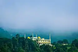
Akurana
Akurana (Sinhala: අකුරණ, Tamil: அக்குரணை) is a suburb of the city of Kandy in the Kandy district of the Central Province of Sri Lanka. The town is situated 125 km (78 mi) from Colombo and 10 km (6.2 mi) from the centre of Kandy. Akurana lies near Katugastota, along the A9 high way. Akurana area came under the local government authority of the Akurana Pradeshiya Sabhawa in late 1980s and included the villages of Alawathugoda, Dunuwila, Bulugohathenna, Kurugoda, Thelumbgahawaththa, Malgamandeniya and Dippitiya.
Akurana | |
|---|---|
 Grand masjid Akurana | |
 Akurana | |
| Coordinates: 7°21′54″N 80°37′02″E | |
| Country | Sri Lanka |
| District | Kandy District |
| Divisional Secretariat | Akurana Division |
| Province | Central Province |
| Government | |
| • Type | Akurana Pradeshiya Sabha |
| • Chairman | I.M. Isthihar |
| Area | |
| • Town | 31.0 km2 (12.0 sq mi) |
| Population (2012) | |
| • Density | 790/km2 (2,045/sq mi) |
| • Metro | 63,397 |
| Time zone | UTC+5:30 (SLST) |
Geographically, it is surrounded by hills and rivers. The Balapitiya Oya, a tributary of Pinga Oya river, runs through Akurana.[1] The majority of the population are ethnic Moors who are predominantly of Arab and Persian origin. Akurana belongs to the Harispattuwa electorate and was represented in Parliament by a former Foreign Minister, Abdul Cader Shahul Hameed, for more than 33 years without interruption.
Climate
It has a relatively cool climate because of its location in the central hills. Average day time temperature is 25 °C (77 °F) and the night is 19 °C (66 °F). In December the temperature drops to an average 19 °C (66 °F) with heavy mist cover during dawn.
Demographics
Akurana is a Moorish majority town. The Moors are all predominantly Muslim. There are sizable communities belonging to other ethnic groups, such as Buddhist Sinhalese and Hindu Tamil. The majority of the people in the town speak Tamil, English and Sinhala.
Population by ethnicity
Source:statistics.gov.lk
Education
There are two national schools in Akurana namely, Azhar College and Akurana Zahira College.[2] Akurana Muslim Balika College is the only government Muslim girls college in Akurana.
In addition to the above schools there are primary feeding schools in the region which include
- Azhar Model Primary School
- Luqmaniya Maha Vidyalaya - Pangollamada
- Kurundugahaela Muslim Vidyalaya
- Thelumbugahawatte Muslim Vidyalaya
- Neerella Muslim Vidyalaya
- Kasawatte Muslim Vidyalaya
Hospital
Zia Hospital is the only government hospital operating in Akurana providing free health care to the public which was opened by the Pakistani President Muhammad Zia-ul-Haq, during the government of President J. R. Jayewardene.[3]
Transport
Akurana is located on the A9 highway which makes it an easily accessible town. The nearest railway station is in Katugastota, which is 4.5 km (2.8 mi) away.
References
- "Symposium on Pinga Oya". www.tropicalclimate.org.
- "Official website". akuranazahira.sch.lk. Retrieved 2020-12-15.