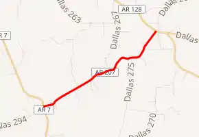
Arkansas Highway 207
Highway 207 (AR 207, Hwy. 207) is a north–south state highway in Dallas County, Arkansas. It was created in 1962 along a former county road. The route is maintained by the Arkansas Department of Transportation (ArDOT). A former designation in the same vicinity was deleted in 1973.
| ||||
|---|---|---|---|---|

| ||||
| Route information | ||||
| Maintained by ArDOT | ||||
| Length | 4.145 mi[1] (6.671 km) | |||
| Existed | March 7, 1962[2]–present | |||
| Major junctions | ||||
| South end | ||||
| North end | ||||
| Location | ||||
| Counties | Dallas | |||
| Highway system | ||||
| ||||
Route description
Highway 207 serves an area of rural Dallas County, part of the Piney Woods region dominated by pine tree plantations.[3] No segment of Highway 207 has been listed as part of the National Highway System,[4] a network of roads important to the nation's economy, defense, and mobility.[5]
Highway 207 begins at Highway 7 three miles (4.8 km) east of the Ouachita River near the unincorporated community of Ouachita. The highway passes through sparsely populated woods in a northeasterly direction to Highway 128, where it terminates. The highway does not cross or concur with any other state highways.[1][6]
The ArDOT maintains Highway 207 like all other parts of the state highway system. As a part of these responsibilities, the Department tracks the volume of traffic using its roads in surveys using a metric called average annual daily traffic (AADT). ARDOT estimates the traffic level for a segment of roadway for any average day of the year in these surveys. As of 2019, AADT was estimated as 60 vehicles per day (VPD) near the southern terminus.[7] For reference, the American Association of State Highway and Transportation Officials (AASHTO), classifies roads with fewer than 400 vehicles per day as a very low volume local road.[8]
Major intersections
The entire route is in Dallas County.
| Location | mi[1] | km | Destinations | Notes | |
|---|---|---|---|---|---|
| | 0.000 | 0.000 | Southern terminus | ||
| | 4.145 | 6.671 | Northern terminus | ||
| 1.000 mi = 1.609 km; 1.000 km = 0.621 mi | |||||
History
The highway was created by the Arkansas State Highway Commission on March 7, 1962, as part of a program adding over 100 miles (160 km) to the state highway system.[2]
Former route
| |
|---|---|
| Location | Dallas County |
| Length | 8.16 mi[9] (13.13 km) |
| Existed | July 10, 1957[10]–May 23, 1973[9] |
Highway 207 (AR 207, Hwy. 207) is a former state highway in Dallas County. It was a rural, two-lane highway connecting Sparkman to Highway 8. The highway did not cross or concur with any other state highways.
- History
The Arkansas General Assembly passed Act 148 of 1957, the Milum Road Act, creating 10–12 miles (16–19 km) of new state highways in each county.[11] Highway 207 was created by the Arkansas State Highway Commission on July 10, 1957 from Sparkman northeast for 2.3 miles (3.7 km).[10] The order was revised to extend Highway 207 another 1.7 miles (2.7 km) on July 9, 1958.[12] The highway was extended again, to Highway 8, on June 29, 1960.[13] It was deleted on May 23, 1973, in an exchange that extended Highway 273 at the request of the Dallas County Judge.[9]
- Major intersections
The entire route was in Dallas County.
| Location | mi[9] | km | Destinations | Notes | |
|---|---|---|---|---|---|
| | 0.00 | 0.00 | Southern terminus | ||
| | 8.16 | 13.13 | Northern terminus | ||
| 1.000 mi = 1.609 km; 1.000 km = 0.621 mi | |||||
See also
References
- Transportation Planning and Policy Division (December 30, 2019). State Highway Route and Section Map, Dallas County (PDF) (Map). Cartography by Geographic Information Systems & Mapping Section. Little Rock: Arkansas Department of Transportation. Retrieved November 30, 2020.
- "Minutes of the Meeting of the Arkansas State Highway Commission" (PDF). Little Rock: Arkansas State Highway Commission. 1953–1969. p. 1045. OCLC 21798861. Retrieved December 1, 2020.
-
 This article incorporates public domain material from the United States Geological Survey document: Woods, AJ; Foti, TL; Chapman, SS; Omernik, JM; et al. "Ecoregions of Arkansas" (PDF). (color poster with map, descriptive text, summary tables, and photographs)
 - System Information and Research Division (2015). "Arkansas Road Log Database" (MDB). Arkansas State Highway and Transportation Department. Retrieved March 27, 2016.
- Natzke, Stefan; Neathery, Mike & Adderly, Kevin (June 29, 2017). "What is the National Highway System?". National Highway System. Federal Highway Administration. Retrieved July 15, 2018.
- Transportation Planning and Policy Division (August 1, 2019) [January 12, 1999]. General Highway Map, Dallas County, Arkansas (PDF) (Map) (Revised ed.). 1:62500. Little Rock: Arkansas Department of Transportation. OCLC 911061628. Retrieved November 30, 2020.
- System Information & Research Division (2017). Annual Average Daily Traffic Estimates (GIS Map) (Map). Various. Arkansas Department of Transportation. Retrieved November 30, 2020.
- Staff of AASHTO (2019). Guidelines for Geometric Design of Low-Volume Roads (2nd ed.). Washington D.C.: American Association of State Highway and Transportation Officials. p. 2-8. ISBN 978-1-56051-726-9. OCLC 1140203768.
- "Minutes of the Meeting of the Arkansas State Highway Commission" (PDF). Little Rock: Arkansas State Highway Commission. 1970–1979. p. 1160. OCLC 21798861. Retrieved December 1, 2020.
- "Minutes" (1953–69), pp. 1782-1783.
- Planning and Research Division, Policy Analysis Section (2010). Development of Highway and Transportation Legislation in Arkansas (PDF). A Review of the Acts Relative to Administering and Financing Highways and Transportation in Arkansas. Little Rock: Arkansas State Highway and Transportation Department. p. 13. Retrieved July 11, 2017.
- "Minutes" (1953–69), p. 1647.
- "Minutes" (1953–69), p. 1358.
