Arkansas Highway 72
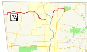
Highway 72 (AR 72, Ark. 72, and Hwy. 72) is a designation for two east–west state highways in Benton County, Arkansas. A western route of 26.32 miles (42.36 km) runs east from Highway 43 at Maysville to U.S. Route 71B (US 71B) in Bentonville.[2] A second route of 12.67 miles (20.39 km) begins at Interstate 49/US Route 71 (I-49/US 71) in Bentonville and runs northeast to US 62 near Avoca.[2] The route is one of the original Arkansas state highways.[3]
| ||||
|---|---|---|---|---|
 | ||||
| Route information | ||||
| Maintained by ArDOT | ||||
| Existed | 1926–present | |||
| Section 1 | ||||
| Length | 26.32 mi[1] (42.36 km) | |||
| West end | ||||
| East end | ||||
| Section 2 | ||||
| Length | 12.67 mi[1] (20.39 km) | |||
| West end | ||||
| East end | ||||
| Location | ||||
| Counties | Benton | |||
| Highway system | ||||
| ||||
Route description

Maysville to Bentonville
The route begins at Highway 43 in Maysville and runs east to Gravette. Highway 72 intersects Highway 59 in Gravette near the Kansas City Southern Railway Caboose No. 383 on the National Register of Historic Places.[4] The highway continues east past the Banks House to Hiwasse, where the highway passes the Hiwasse Bank Building. Upon reaching Hiwasse Highway 72 has an officially designated exception of 0.52 miles (0.84 km) with Highway 279 near .[5] The highway runs southeast into Centerton. Highway 72 has a junction with Highway 102B before entering Bentonville. In Bentonville the highway becomes Central Avenue, running east through subdivisions until meeting US 71B and terminating a few blocks west of the Bentonville town square.
Bentonville to Avoca
Highway 72 begins at I-49/US 71 in Bentonville and runs northeast to Pea Ridge. The highway has an overlap with Highway 94 through Pea Ridge before turning southeast and runs through Pea Ridge National Military Park. South of the park Highway 72 terminates at US 62.
History
Between Bentonville and Gravette, Highway 72 follows a former alignment of U.S. Route 71. In the late 1990s Highway 72 was rerouted away from downtown Bentonville along US 71B, Highway 102, and Highway 112.
Major intersections
The entire route is in Benton County.
| Location | mi[1] | km | Destinations | Notes | |||
|---|---|---|---|---|---|---|---|
| Maysville | 0.00 | 0.00 | |||||
| Gravette | West end of AR 59 overlap | ||||||
| East end of AR 59 overlap | |||||||
| Future I-49 exit 287 | |||||||
| 15.20 | 24.46 | West end of AR 279 overlap | |||||
| 15.72 | 25.30 | East end of AR 279 overlap | |||||
| Future I-49 exit 284 | |||||||
| Centerton | |||||||
| Bentonville | 26.32 | 42.36 | |||||
| Gap in route | |||||||
| 0.00 | 0.00 | I-49 exit 88A-B | |||||
| Pea Ridge | 6.79 | 10.93 | West end of AR 94 overlap | ||||
| 7.72 | 12.42 | East end of AR 94 overlap | |||||
| | 12.67 | 20.39 | |||||
1.000 mi = 1.609 km; 1.000 km = 0.621 mi
| |||||||
Bentonville spur
| |
|---|---|
| Location | Bentonville |
| Length | 1.0 mi (1.6 km) |
Highway 72 Spur (AR 72B, Ark. 72B, and Hwy. 72B) is a former spur route in Bentonville. Its southern terminus was at an intersection with U.S. Route 71 (now U.S. Route 71B ) with a northern terminus at an intersection with Arkansas Highway 72 (aka Central Ave) in Bentonville. Running a total distance of 1-mile (1.6 km), it was an older alignment of U.S. 71 and at one time was part of U.S. Route 71B.
See also
References
- Planning and Research Division (March 28, 2012). "Arkansas Road Log Database". Arkansas State Highway and Transportation Department. Archived from the original (MBD) on June 23, 2011. Retrieved April 13, 2012.
- General Highway Map, Benton County, Arkansas (PDF) (Map). 1:62500. Cartography by Planning and Research Division. Arkansas State Highway and Transportation Department. February 10, 2012. Retrieved April 20, 2012.
- Limerick, R. C. (1926). State Highway System of the State of Arkansas (Map) (Original ed.). Arkansas State Highway Commission. Archived from the original on June 22, 2011. Retrieved May 10, 2012.
- "National Register Information System". National Register of Historic Places. National Park Service. July 9, 2010.
- Route and Section Map - Benton County, Arkansas (PDF) (Map). Cartography by Planning and Research Department. Arkansas State Highway and Transportation Department. Retrieved May 10, 2012.
External links
![]() Media related to Arkansas Highway 72 at Wikimedia Commons
Media related to Arkansas Highway 72 at Wikimedia Commons
