Badger Mountain (Douglas County, Washington)
Badger Mountain is a mountain in Douglas County in the U.S. state of Washington. It is the highest point in Douglas County[2] and is located east of the Columbia River and northeast of Wenatchee. Badger Mountain is part of the Columbia Plateau.
| Badger Mountain; Formerly known as Mount St. Pierre | |
|---|---|
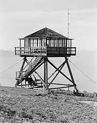
 Fire lookout on top of Badger Mountain | |
| Highest point | |
| Elevation | 4,262 ft (1,299 m) NAVD 88[1] |
| Prominence | 2,674 ft (815 m) [2] |
| Coordinates | 47°35′02″N 120°10′46″W [1] |
| Geography | |
 Badger Mountain; Formerly known as Mount St. Pierre | |
| Parent range | Columbia River Plateau |
| Topo map | USGS Orondo |
The Badger Mountain Ski Area is located on the mountain's northeastern flank.
Formerly named after the useful Native American and European - Peter (Pierre) Charles.
References
- "Ski". NGS data sheet. U.S. National Geodetic Survey. Retrieved 2010-12-29.
- "Badger Mountain, Washington". Peakbagger.com. Retrieved 2008-10-02.
External links
- "Badger Mountain". Geographic Names Information System. United States Geological Survey.
- "Badger Mountain". SummitPost.org. Retrieved 2011-05-07.
This article is issued from Wikipedia. The text is licensed under Creative Commons - Attribution - Sharealike. Additional terms may apply for the media files.