Baldenweger Buck
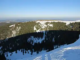
The Baldenweger Buck is a mountain top, 1,460.5 m above sea level (NHN),[1] in the Black Forest around 900 metres northeast of the Feldberg summit.
| Baldenweger Buck | |
|---|---|
 The Baldenweger Buck from the summit of the Feldberg | |
| Highest point | |
| Elevation | 1,460.5 m above sea level (NHN) (4,792 ft) |
| Prominence | 7.7 m |
| Isolation | 0.52 km |
| Coordinates | 47°52′36″N 8°00′56″E |
| Geography | |
 Baldenweger Buck | |
| Parent range | Black Forest |
The bare ridge drops steeply towards the west, north and east into the surrounding valleys of the Zastlerbach and Seebach. Only towards the south does it transition into a shallow saddle (1,452.8 m) that links the Baldenweger Buck with the Feldberg top.
With its low isolation of 520 metres and a prominence of only 7.7 metres to the Feldberg, the Baldenweger Buck is not considered to be an independent eminence, but a subpeak of the Feldberg. As a result, the second highest summit in the Black Forest is usually seen as the lower, but more prominent, Seebuck.
A waymarked footpath runs over the Baldenweger Buck from the Rinken via the Baldenweger Hut to the summit of the Feldberg.
References
- Map services of the Federal Agency for Nature Conservation