Boon Farm
Boon is a farm and former barony[1] located near Lauder, Scotland.
| Boon Farm | |
|---|---|
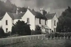
 Boon Farmhouse in 1924 | |
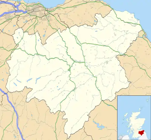
 Boon Farm Location within the Scottish Borders | |
| OS grid reference | NT574465 |
| Council area | |
| Lieutenancy area | |
| Country | Scotland |
| Sovereign state | United Kingdom |
| Postcode district | TD2 |
| Police | Scotland |
| Fire | Scottish |
| Ambulance | Scottish |
| UK Parliament | |
| Scottish Parliament | |
History
Name Origins
Boon (aka "Boune" or "Bounn"), derives from the Breton word bonn, meaning "boundary", or "limit".[2]
Prior to the 17th Century
Boon Farm, a part of the former Legerwood parish, was carved out of lands that were originally covered in thick woodlands. The Picts, Romans, Anglo-Saxons, Britons, and Scots, successive possessors of this region, consumed the greater part of these woods through the ravages of war, in opening passages through the country, for domestic uses, and in clearing the ground for cultivation.[3]
The remains of an ancient wall, or earthen mound with a ditch on one side, known as The Black Dyke, or Heriot's Dyke, runs eastward from Boon towards Greenlaw and the coast at Berwick. It is not known by whom or at what time this wall was built, nor for what purpose it was intended.[4][5][6]
Up until the 12th century, the lands of Birkenside, Whitslaid, Legerwood, and the Morristons (near Earlston) were public lands. David I held these lands as his demesne, and in 1160, his grandson Malcolm IV granted the lands of Birkenside and Legerwood to Walter fitz Alan. The lands remained in the possession of the Stewart family until Robert II granted the lands of Birkenside, Legerwood, and Morriston to Alan de Lawedre (father of Robert de Lawedre of Edrington) on 13 June 1371.[7]
17th Century and 18th Centuries
By the mid 17th century, the woodland had been almost completely cleared, except for a small remnant called Bounwoode which lay tucked up against the Boondreigh Water, a small burn that runs along the northern boundary of Legerwood before joining the Leader river to the west.[8]
After the widespread destruction of the native woods, the higher, hilly sections were overtaken by heath, and the lower and flat tracts became water-filled bogs and marshes. Small farm-steads with narrow fields were the norm for most of the 17th and early 18th centuries.[3]
The family of Lauder were still in possession of the lands until 1666 when Boon, and nearby Corsbie, were given as a dowry to Lady Mary Maitland, the daughter of John Maitland, 1st Duke of Lauderdale, when she married John Hay, 2nd Marquess of Tweeddale.[4]
Boon Farm was continuously farmed by the Mirtle family from the late 1600s until 1810.
19th Century
On 31 January 1810 John Mirtle of Boon Farm, uncle of William Mirtle, died at the advanced age of 95, leaving no heirs.[9] The farm passed through unknown hands until 1872, where Dr. Robert Shirra Gibb took over the lease and worked the lands for 50 years, until retiring in 1922.[4]
Boon Hill
At 1070 feet above sea level, Boon Hill is a prominent eminence rising above the fields of Boon Farm and the surrounding countryside. During the reign of Queen Anne, there was a small fort on top of the hill which housed a Sergeant and two soldiers, stationed there to man the beacon hut. Portions of the fort remained standing until 1840, when they were blown down during a windstorm. The landowner, the Marquess of Tweeddale, ordered a small tower to be built upon the hill to commemorate the site of the old fort.[4]
Dod's Corse Stone
Located near the base of Boon Hill, Dod's Corse Stone is an ancient shaft of sandstone sticking out of a block of the same material, inscribed with a cross on opposite sides. It was placed at the site of an old marketplace, according to local tradition.[10]
The stone commemorates a duel between Johnne Cranstoun, brother of Patrick Cranstoun of Corsbie, and Alexander Frenche on 13 March 1612. Frenche and his accomplice, James Wicht, were tried and sentenced to beheading.[11]
Boon Farm today
Boon Farm was the site of a proposed wind farm, which would have seen up to 21 wind turbines placed on Corsbie Moor.[12][13] The proposal was ultimately rejected.[13][14]
Gallery
 Bounwoode and Bounn Mill in 1654, as shown on the Blaeu Atlas of Scotland
 Boon hill, showing remains of a wall and a triangulation station
.jpg.webp) Map of Boon Farm, including notable landmarks, 1924
Map of Boon Farm, including notable landmarks, 1924 Dod's Corse Stone
References
- McNeill, Peter; MacQueen, Hector (1996). An Atlas of Scottish History to 1707. University of Edinburgh. p. 204.
- Goodrich, Chauncey A.; Porter, Noah (1864). New Illustrated Edition of Dr. Webster's Unabridged Dictionary of the English Language. Bell and Daldy, London. p. 155.
- Sinclair, Sir John (1795). "Parish of Legerwood". The Statistical Account of Scotland. XVI: 484–485.
- Shirra Gibb, Dr. Robert (1927). A Farmer's Fifty Years in Lauderdale. Oliver and Boyd. pp. 50–52.
- Cosens, Rev. Peter (1845). "Parish of Lauder". The New Statistical Account of Scotland. II: 43.
- "Heriot's Dyke, Greenlaw Moor". Canmore.org.uk. Retrieved 10 May 2018.
- Walker, Rev. John (1845). "Parish of Legerwood". The New Statistical Account of Scotland. II: 351–353.
- "Berwickshire OS Name Books, 1856-1858: OS1/5/28/102". scotlandsplaces.gov.uk. Retrieved 2 May 2018.
- "Births and Deaths". The Scots Magazine and Edinburgh Miscellany. LXXII: 239. 1810.
- "Berwickshire OS Namebooks, 1856-1858: OS1/5/30/19". scotlandsplaces.gov.uk. Retrieved 17 May 2018.
- Pitcairn, Robert (1830). Criminal Trials and Other Proceedings Before the High Court of Justicary Part VII (1611 - 1616). Ballantyne and Co. pp. 222–223.
- "Millionaire aristo fights wind farm with warning over 'lure of riches'". The Southern Reporter. 3 September 2011. Retrieved 22 March 2018.
- "E.On Corsbie Moor wind farm rejected". BBC. 4 September 2012. Retrieved 22 March 2018.
- "Corsbie Moor wind farm refusal appeal dismissed". The Southern Reporter. 5 September 2013. Retrieved 22 March 2018.