Brucheville
Brucheville is a former commune in the Manche department in Normandy in northwestern France. On 1 January 2019, it was merged into the commune Carentan-les-Marais.[2] It is located at the south east corner of the Cherbourg peninsula, about 90 km east of Caen.
Brucheville | |
|---|---|
Part of Carentan-les-Marais | |
.JPG.webp) The church of Saint-Hilaire | |
Location of Brucheville 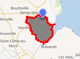
| |
 Brucheville 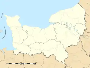 Brucheville | |
| Coordinates: 49°22′25″N 1°12′18″W | |
| Country | France |
| Region | Normandy |
| Department | Manche |
| Arrondissement | Saint-Lô |
| Canton | Carentan |
| Commune | Carentan-les-Marais |
| Area 1 | 13.33 km2 (5.15 sq mi) |
| Population (2017)[1] | 141 |
| • Density | 11/km2 (27/sq mi) |
| Time zone | UTC+01:00 (CET) |
| • Summer (DST) | UTC+02:00 (CEST) |
| Postal code | 50480 |
| Elevation | 0–21 m (0–69 ft) (avg. 4 m or 13 ft) |
| 1 French Land Register data, which excludes lakes, ponds, glaciers > 1 km2 (0.386 sq mi or 247 acres) and river estuaries. | |
World War II
After the liberation of the area by Allied Forces in 1944, engineers of the Ninth Air Force IX Engineering Command began construction of a combat Advanced Landing Ground outside of the town. Declared operational on 2 August, the airfield was designated as "A-16", it was used by the 36th Fighter Group which flew P-47 Thunderbolts until late August when the unit moved into Central France. Afterward, the airfield was closed.[3][4]
Population
| Year | Pop. | ±% |
|---|---|---|
| 1793 | 372 | — |
| 1800 | 374 | +0.5% |
| 1806 | 468 | +25.1% |
| 1821 | 456 | −2.6% |
| 1831 | 334 | −26.8% |
| 1836 | 342 | +2.4% |
| 1841 | 339 | −0.9% |
| 1846 | 345 | +1.8% |
| 1851 | 338 | −2.0% |
| 1856 | 303 | −10.4% |
| 1861 | 294 | −3.0% |
| 1866 | 301 | +2.4% |
| 1872 | 274 | −9.0% |
| 1876 | 309 | +12.8% |
| 1881 | 292 | −5.5% |
| 1886 | 300 | +2.7% |
| 1891 | 296 | −1.3% |
| 1896 | 278 | −6.1% |
| 1901 | 261 | −6.1% |
| 1906 | 255 | −2.3% |
| 1911 | 237 | −7.1% |
| 1921 | 255 | +7.6% |
| 1926 | 263 | +3.1% |
| 1931 | 228 | −13.3% |
| 1936 | 245 | +7.5% |
| 1946 | 237 | −3.3% |
| 1954 | 223 | −5.9% |
| 1962 | 204 | −8.5% |
| 1968 | 207 | +1.5% |
| 1975 | 181 | −12.6% |
| 1982 | 174 | −3.9% |
| 1990 | 140 | −19.5% |
| 1999 | 147 | +5.0% |
| 2007 | 149 | +1.4% |
| 2009 | 145 | −2.7% |
See also
References
- Téléchargement du fichier d'ensemble des populations légales en 2017, INSEE
- Arrêté préfectoral 6 December 2018 (in French)
- Johnson, David C. (1988), U.S. Army Air Forces Continental Airfields (ETO), D-Day to V-E Day; Research Division, USAF Historical Research Center, Maxwell AFB, Alabama.
- Maurer, Maurer. Air Force Combat Units of World War II. Maxwell AFB, Alabama: Office of Air Force History, 1983. ISBN 0-89201-092-4.
| Wikimedia Commons has media related to Brucheville. |
| Authority control |
|
|---|
This article is issued from Wikipedia. The text is licensed under Creative Commons - Attribution - Sharealike. Additional terms may apply for the media files.