California Historical Landmarks in Santa Clara County, California
List table of the properties and districts — listed on the California Historical Landmarks — within Santa Clara County, California.
- Note: Click the "Map of all coordinates" link to the right to view a Google map of all properties and districts with latitude and longitude coordinates in the table below.
Listings
| Image | [1] | Landmark name | Location | City or town | Summary |
|---|---|---|---|---|---|
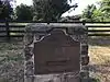
 Almaden Vineyards |
505 | Almaden Vineyards | 1530 Blossom Hill Rd. 37°14′21″N 121°53′41″W |
San Jose | |
 Arroyo de San José Cupertino |
800 | Arroyo de San José Cupertino | Monta Vista High School 37°18′56″N 122°03′28″W |
Cupertino | |
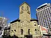
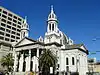 Cathedral Basilica of St. Joseph |
910 | Cathedral Basilica of St. Joseph | 90 S Market St. 37°20′03″N 121°53′27″W |
San Jose | Also on the NRHP list as NPS-77000365, St. Joseph's Roman Catholic Church |
 Charles Copeland Morse House |
904 | Charles Copeland Morse House | 981 Fremont St. 37°21′07″N 121°56′44″W |
Santa Clara | Also on the NRHP list as NPS-82002266 |
 Eadweard Muybridge and the development of motion pictures |
834 | Eadweard Muybridge and the development of motion pictures | Stanford University, Campus Dr W across from Stanford Driving Range 37°25′29″N 122°10′57″W |
Stanford | |
| 416 | Edwin Markham Home | Kelley Park, 1600 Senter Rd. 37°19′13″N 121°51′33″W |
San Jose | ||
| 945 | First successful introduction of the honeybee to California | San Jose Municipal Airport, 1661 Airport Blvd. 37°21′N 121°55′W |
San Jose | ||
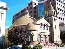 First Unitarian Church of San Jose |
902 | First Unitarian Church of San Jose | 160 N. Third St. 37°20′23″N 121°53′24″W |
San Jose | Also on the NRHP list as NPS-77000343 |
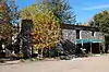 Forbes Mill |
458 | Forbes Mill | Forbes Mill Museum 37°13′20″N 121°58′49″W |
Los Gatos | |
 First site of El Pueblo de San José de Guadalupe |
433 | First site of El Pueblo de San José de Guadalupe | Former San Jose City Hall at Civic Center 37°21′00″N 121°54′13″W |
San Jose | |
| 1017 | Gilroy Yamato Hot Springs | 37°06′30″N 121°28′39″W |
Gilroy | Also on the NRHP list as NPS-95000996 | |
 Guadalupe Mission of San Jose |
1049 | Guadalupe Mission of San Jose | 37°21′09″N 121°50′41″W |
San Jose | Also on the NRHP list as NPS-100000836 |
| 447 | Gubserville | 1481 Saratoga Ave. 37°17′44″N 121°59′16″W |
San Jose | ||
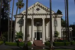
 Hayes Mansion |
888 | Hayes Mansion | 200 Edenvale Ave. 37°15′44″N 121°49′15″W |
San Jose | |
 HP Garage |
976 | HP Garage | 367 Addison Ave. 37°26′35″N 122°09′17″W |
Palo Alto | Also on the NRHP list as NPS-07000307 |
 Hostess House |
895 | Hostess House | 27 Mitchell Ln. 37°26′35″N 122°09′56″W |
Palo Alto | Also on the NRHP list as NPS-76000528 |
 John Adams Squire House |
857 | John Adams Squire House | 900 University Ave. 37°27′12″N 122°09′12″W |
Palo Alto | Also on the NRHP list as NPS-72000255 |
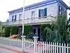
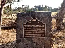 Juana Briones de Miranda Home |
524 | Juana Briones de Miranda Home | 4157 Old Adobe Rd. 37°23′32″N 122°08′22″W |
Palo Alto | |
| 903 | Kotani-En | 15891 Ravine Rd. |
Los Gatos | ||
 Lou Henry Hoover House |
913 | Lou Henry Hoover House | 623 Mirada Rd. 37°25′07″N 122°10′03″W |
Stanford | |
 Martin Murphy Home and Estate |
644 | Martin Murphy Home and Estate | Martin Murphy, Jr. Historical Park |
Sunnyvale | |
 Sarah Wallis Mayfield Farm |
969 | [[Sarah Wallis Mayfield Farm|Sarah Wallis Mayfield Farm]] | 3880 La Selva Drive 37°24′59″N 122°07′49″W |
Palo Alto | Historic marker |
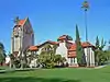
 Mission Santa Clara de Asis |
338 | Mission Santa Clara de Asis | Mission Church, University of Santa Clara 37°20′57″N 121°56′30″W |
Santa Clara | |
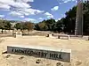 Montgomery Hill |
813 | Montgomery Hill | Corner of San Felipe Road and Yerba Buena Road 37°17′57″N 121°46′16″W |
San Jose | |
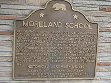 Moreland School |
489 | Moreland School | 4335 Payne Ave. 37°18′03″N 121°58′45″W |
San Jose | |
| 339 | New Almaden Mine | On N-bound old Hwy 101 37°14′54″N 121°47′20″W |
San Jose | ||
| 339-1 | New Almaden Mine | Bulmore Park, Almaden Rd and Almaden Way 37°10′27″N 121°49′28″W |
San Jose | ||
 Old Post Office |
854 | Old Post Office | 110 S. Market St. 37°20′01″N 121°53′25″W |
San Jose | |
 Old site of Mission Santa Clara de Asis and Old Spanish Bridge |
250 | Old site of Mission Santa Clara de Asis and Old Spanish Bridge | De La Cruz Blvd. and Martin Ave. 37°21′59″N 121°56′29″W |
Santa Clara | |
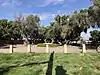
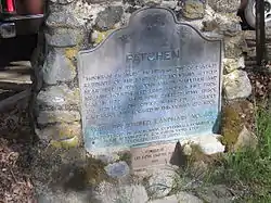 Patchen |
448 | Patchen | Old Santa Cruz Hwy and Mountain Charlie Rd. 37°08′53″N 121°58′27″W |
Holy City | |
 Paul Masson Mountain Winery |
733 | Paul Masson Mountain Winery | Mountain Winery 37°15′37″N 122°03′54″W |
Saratoga | Also on the NRHP list as NPS-83001239 |
 Pellier Park, site of City Gardens |
434 | Pellier Park, site of City Gardens | 100 block of W St James St. 37°20′16″N 121°53′45″W |
San Jose | |
Peralta Adobe |
866 | Peralta Adobe | 900 University Ave. 37°20′11″N 121°53′41″W |
San Jose | Also on the NRHP list as NPS-73000454 |
| 836 | Pioneer Electronics Research Laboratory | SE corner of Channing Ave. and Emerson St. 37°26′29″N 122°09′28″W |
Palo Alto | ||
 Roberto Adobe and Suñol House |
898 | Roberto Adobe and Suñol House | 770 Lincoln Ave. 37°18′57″N 121°54′23″W |
San Jose | |
 San Jose State College |
417 | San Jose State College | San Jose State University 37°20′08″N 121°52′52″W |
San Jose | |
 Santa Clara Campaign Treaty Site |
260 | Santa Clara Campaign Treaty Site | Civic Center Park 37°21′08″N 121°57′13″W |
Santa Clara | |
 Saratoga |
435 | Saratoga | Hwys 9 and 85 37°15′33″N 122°01′51″W |
Saratoga | |
 Site of California's First State Capitol |
461 | Site of California's First State Capitol | City Park Plaza 37°19′58″N 121°53′23″W |
San Jose | |
 Site of invention of the first commercially practicable integrated circuit |
1000 | Site of invention of the first commercially practicable integrated circuit | 844 E Charleston Rd. 37°25′18″N 122°06′12″W |
Palo Alto | |
| 952 | Site of the world's first broadcasting station | First and San Fernando Sts. 37°20′03″N 121°53′22″W |
San Jose | ||
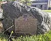
 Vasquez Tree and site of 21-Mile-House |
259 | Vasquez Tree and site of 21-Mile-House | Tennant Ave. and Monterey Hwy. 37°06′47″N 121°38′38″W |
Morgan Hill | |
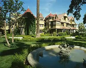 Winchester Mystery House |
868 | Winchester Mystery House | 525 S. Winchester Blvd. 37°19′06″N 121°57′03″W |
San Jose | Also on the NRHP list as NPS-74000559 |
 Women's Club Adobe |
249 | Women's Club Adobe | 3260 The Alameda between Benton and Franklin Sts. 37°21′07″N 121°56′27″W |
Santa Clara |
References
- "California Historical Landmarks By County". Ohp.parks.ca.gov. Retrieved 2019-04-03.
See also
| Wikimedia Commons has media related to California Historical Landmarks in Santa Clara County, California. |
This article is issued from Wikipedia. The text is licensed under Creative Commons - Attribution - Sharealike. Additional terms may apply for the media files.