Capão Bonito
Capão Bonito is a municipality in the state of São Paulo in Brazil. The population is 47,118 (2020 est.) in an area of 1640 km².[1] The elevation is 705 m.
Capão Bonito | |
|---|---|
 Igreja Matriz | |
 Flag  Coat of arms | |
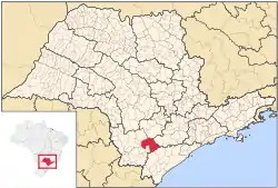
 Location in São Paulo state | |
 Capão Bonito Location in Brazil | |
| Coordinates: 24°0′21″S 48°20′58″W | |
| Country | Brazil |
| Region | Southeast |
| State | São Paulo |
| Area | |
| • Total | 1,640 km2 (630 sq mi) |
| Population (2020 [2]) | |
| • Total | 47,118 |
| • Density | 29/km2 (74/sq mi) |
| Time zone | UTC-03:00 (BRT) |
| • Summer (DST) | UTC-02:00 (BRST) |
The municipality contains part of the 37,644 hectares (93,020 acres) Carlos Botelho State Park, created in 1982.[3] It contains part of the 488,865 hectares (1,208,010 acres) Serra do Mar Environmental Protection Area, created in 1984.[4] It also contains the 22,269 hectares (55,030 acres) Nascentes do Paranapanema State Park, created in 2012.[5]
References
- Instituto Brasileiro de Geografia e Estatística
- IBGE 2020
- Sobre o Parque (in Portuguese), SAP: Sistema Ambiental Paulista, retrieved 2016-12-07
- APA da Serra do Mar (APA) (in Portuguese), ISA: Instituto Socioambiental, retrieved 2016-12-08
- Alckmin, Geraldo; Covas, Bruno (22 June 2012), "Decreto nº 58.148, de 21 de Junho de 2012", Diário Oficial (in Portuguese), Government of São Paulo, 122 (116), retrieved 2016-12-06
This article is issued from Wikipedia. The text is licensed under Creative Commons - Attribution - Sharealike. Additional terms may apply for the media files.