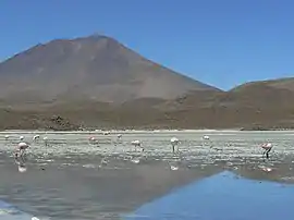
Cerro Araral
Cerro Araral is a mountain located in the Andes on the border between Chile and Bolivia in the Potosí Department and in the Antofagasta Region. It has a height of 5647 metres, rising over a base of 3900 metres and covers an area of 109.4 square kilometres (42.2 sq mi). The edifice has a volume of 43.4 cubic kilometres (10.4 cu mi), down from 47.2 cubic kilometres (11.3 cu mi) due to erosion. Based on the erosion rate, the volcano is 1.9 million years old.[1] The modern snowline on the mountain lies at more than 5,700 metres (18,700 ft) altitude.[3] The volcanism is at first andesitic and later becomes intermediary between andesite and basalt.[4]
| Cerro Araral | |
|---|---|
 | |
| Highest point | |
| Elevation | 5,647 m (18,527 ft) [1] |
| Coordinates | 21°37′S 68°13′W [2] |
| Geography | |
 Cerro Araral Location in Bolivia, on the border with Chile | |
| Location | Bolivia-Chile |
| Parent range | Andes |
See also
References
- Karátson, D.; Telbisz, T.; Wörner, G. (February 2012). "Erosion rates and erosion patterns of Neogene to Quaternary stratovolcanoes in the Western Cordillera of the Central Andes: An SRTM DEM based analysis". Geomorphology. 139–140: 122–135. doi:10.1016/j.geomorph.2011.10.010.
- Ochsenius, Claudio (1986). "La Glaciación Puna durante el Wisconsin, Desglaciación y Máximo Lacustre en la Transición Wisconsin-Holoceno y Refugios de Megafauna Postglaciales en la Puna y Desierto de Atacama" (PDF). Revista de Geografía Norte Grande (in Spanish). 29–58 (13). Archived from the original (PDF) on 2016-03-04. Retrieved 13 September 2015.
- Ram Bali Singh (1 January 1992). Dynamics of Mountain Geosystems. APH Publishing. p. 165. ISBN 978-81-7024-472-1.
- Zeil, Werner (December 1959). "Junger Vulkanismus in der Hochkordillere der Provinz Antofagasta (Chile)". Geologische Rundschau (in German). 48 (1): 218–232. doi:10.1007/BF01801827. ISSN 1432-1149.
This article is issued from Wikipedia. The text is licensed under Creative Commons - Attribution - Sharealike. Additional terms may apply for the media files.