Cockeysville Marble
The Cockeysville Marble is a Precambrian, Cambrian, or Ordovician marble formation in Baltimore, Carroll, Harford and Howard Counties, Maryland. It is described as a predominantly metadolomite, calc-schist, and calcite marble, with calc-gneiss and calc-silicate marble being widespread but minor.[1]
| Cockeysville Marble Stratigraphic range: Precambrian, Cambrian, or Ordovician | |
|---|---|
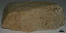
 Polished slab of the marble from Cockeysville. Width of slab inside black border is approximately 10.7 cm. | |
| Type | metamorphic |
| Unit of | Glenarm Supergroup |
| Underlies | Wissahickon Formation |
| Overlies | Setters Formation |
| Thickness | about 750 feet[1] |
| Lithology | |
| Primary | marble |
| Location | |
| Region | Piedmont of Maryland |
| Type section | |
| Named for | Cockeysville, Maryland |
| Named by | Williams and Darton, 1892[2] |
The extent of this formation was originally mapped in 1892[2] within Baltimore County.
Quarrying
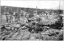
The Cockeysville Marble has been quarried in Beaver Dam within Cockeysville and other locations in Maryland. A historical account is given in Maryland Geological Survey Volume Two.[3]
The Cockeysville was also mined for crushed stone at what is now called Quarry Lake.[4] It was known as the McMahon Quarry in the 1940s.
The Washington Monument in Baltimore and the one in Washington, D.C. are constructed from the Cockeysville Marble.
See also
References
- Geologic Map of Maryland, 1968. Cleaves, E. T., Edwards, J. Jr., and Glaser, J. D. Maryland Geological Survey. Scale 1:250,000.
- Williams, G.H., and Darton, N.H., 1892, Geologic map of Baltimore and vicinity: U.S. Geological Survey, Map to accompany "Guide to Baltimore".
- Maryland Geological Survey Volume Two, by W. B. Clark, 1898. Johns Hopkins University Press. (Google Books)
- McMahon Quarry (Greensberg Quarry), Bare Hills, Baltimore Co., Maryland, USA