Colorado State Highway 15
State Highway 15 in the U.S. state of Colorado is a north–south, then east–west, state highway in the San Luis Valley region of Southern Colorado. It connects the two towns of Monte Vista and La Jara. There is a gap in the route.
| ||||
|---|---|---|---|---|
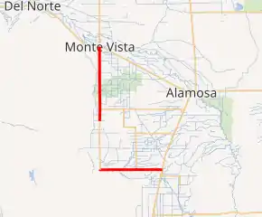
SH 15 highlighted in red | ||||
| Route information | ||||
| Maintained by CDOT | ||||
| Length | 22.834 mi[1] (36.748 km) | |||
| Major junctions | ||||
| North end | ||||
| East end | ||||
| Location | ||||
| Counties | Rio Grande, Conejos | |||
| Highway system | ||||
Colorado State Highways
| ||||

Route description
The route begins at a concurrency between US 285 and US 160. After about 12 miles, at the Rio Grande-Conejos county line, there exists an eight-mile gap[1] filled in by Conejos County Route 6.[2] After the gap, SH 15 reappears, crosses over the La Jara Creek, and ends at US 285 south of Alamosa.
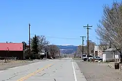
SH 15 looking west in Capulin
History
The route was established in the 1920s as a much longer route, but it was gradually cut down to its current length. The route was paved in 1957.[2]
Major intersections
| County | Location | mi[1] | km | Destinations | Notes | ||
|---|---|---|---|---|---|---|---|
| Rio Grande | Monte Vista | 0.000 | 0.000 | Northern terminus; highway continues as US 285 north (Broadway north) | |||
| | 10.41 | 16.75 | |||||
| Rio Grande–Conejos county line | | 12.37 | 19.91 | End state maintenance | |||
| Road 6 continues south | |||||||
| Conejos | | 20.39 | 32.81 | Begin state maintenance | |||
| | 26.56 | 42.74 | |||||
| | 30.915 | 49.753 | Eastern terminus | ||||
| 1.000 mi = 1.609 km; 1.000 km = 0.621 mi | |||||||
References
- "Segment list for SH 15". Retrieved 2007-05-12.
- "Colorado Routes 1-19". Retrieved April 1, 2010.
External links
This article is issued from Wikipedia. The text is licensed under Creative Commons - Attribution - Sharealike. Additional terms may apply for the media files.