Copt Hewick
Copt Hewick is a village and civil parish in the Harrogate district of North Yorkshire, England.[2][3] The village lies about two miles east of Ripon. It had a population of 180 in 2004 according to the North Yorkshire County Council, increasing to 253 at the 2011 census.[1]
| Copt Hewick | |
|---|---|
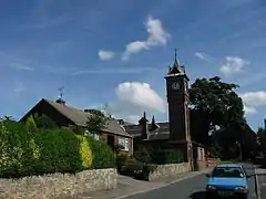
 The clock tower of Copt Hewick Village Hall | |
 Copt Hewick Location within North Yorkshire | |
| Population | 253 (Including Bridge Hewick and Givendale, 2011 census)[1] |
| OS grid reference | SE3375570974 |
| District | |
| Shire county | |
| Region | |
| Country | England |
| Sovereign state | United Kingdom |
| Post town | RIPON |
| Postcode district | HG4 |
| Police | North Yorkshire |
| Fire | North Yorkshire |
| Ambulance | Yorkshire |
The name of the village derives from the Old English Coppede hēah wīc, which means High specialised farm. The Copt element refers to the hill that the village stands on.[4]
References
- UK Census (2011). "Local Area Report – Copt Hewick Parish (E04007328)". Nomis. Office for National Statistics. Retrieved 1 April 2019.
- Ordnance Survey: Landranger map sheet 99 Northallerton & Ripon (Pateley Bridge & Leyburn) (Map). Ordnance Survey. 2013. ISBN 9780319231593.
- "Ordnance Survey: 1:50,000 Scale Gazetteer" (csv (download)). www.ordnancesurvey.co.uk. Ordnance Survey. 1 January 2016. Retrieved 18 February 2016.
- Ekwall, Eilert (1960). The concise Oxford dictionary of English place-names (4 ed.). Oxford: Oxford University Press. p. 237. ISBN 0-19-869103-3.
This article is issued from Wikipedia. The text is licensed under Creative Commons - Attribution - Sharealike. Additional terms may apply for the media files.