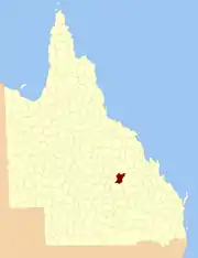
County of Plantagenet, Queensland
The County of Plantagenet is one of the lands administrative divisions of Queensland that has existed since 1901. It is located in the Central Highlands Region of Central Queensland.[1]
| Plantagenet Queensland | |||||||||||||||
|---|---|---|---|---|---|---|---|---|---|---|---|---|---|---|---|
 Location within Queensland | |||||||||||||||
| |||||||||||||||
Parishes
It contains the following parishes:
| Parish | LGA | Coordinates | Towns |
|---|---|---|---|
| Anakie | Central Highlands | 23°30′S 147°51′E | Anakie |
| Argyll | Central Highlands | 23°28′S 147°26′E | |
| Ducabrook | Central Highlands | 23°55′S 147°20′E | |
| Dunstable | Central Highlands | 24°03′S 147°38′E | |
| Echo Hills | Central Highlands | 24°03′S 147°26′E | |
| Glendarriwell | Central Highlands | 23°36′S 147°50′E | |
| Kilsyth | Central Highlands | 24°03′S 147°15′E | |
| Maaland | Central Highlands | 24°09′S 147°09′E | |
| Medway | Central Highlands | 23°48′S 147°20′E | |
| Narcissus | Central Highlands | 24°09′S 147°23′E | |
| Raymond | Central Highlands | 24°09′S 147°37′E | |
| Riddell | Central Highlands | 23°43′S 147°47′E | |
| Rutland | Central Highlands | 23°53′S 147°41′E | |
| Southernwood | Central Highlands | 23°39′S 147°42′E | |
| Tresswell | Central Highlands | 24°14′S 147°30′E | |
| Wilford | Central Highlands | 23°50′S 147°33′E | |
| Withersfield | Central Highlands | 23°35′S 147°30′E | |
| Woodbine | Central Highlands | 23°42′S 147°28′E | |
| Zamia | Central Highlands | 23°37′S 147°18′E | Bogantungan |
This article is issued from Wikipedia. The text is licensed under Creative Commons - Attribution - Sharealike. Additional terms may apply for the media files.