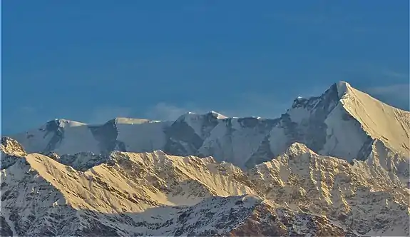
Devtoli
Devtoli (Hindi: देवटोली) is a mountain of Garhwal Himalaya in Uttarakhand India. It stands at 6,788 metres (22,270 ft). It is 36th highest located entirely within the uttrakhand India. Nanda Devi is the highest mountain in this category. It is located at the southern rim of Nanda Devi Sanctuary. Devtoli is located just north west of Maiktoli (6,803 metres (22,320 ft)) and east of Mrigthuni (6,855 metres (22,490 ft)). On the north east side lies Nanda Devi (7,816 metres (25,643 ft)) and Panwali Dwar (6,663 metres (21,860 ft)) on the east side. Tharkot on the southern side.
| Devtoli | |
|---|---|
 Mrigthuni, Devtoli and Maiktoli from Dhakuri top Devtoli in the center | |
| Highest point | |
| Elevation | 6,788 m (22,270 ft) [1] |
| Prominence | 96 m (315 ft) [2] |
| Coordinates | 30°17′09″N 79°51′12″E |
| Geography | |
 Devtoli Location in Uttarakhand | |
| Location | Uttarakhand, India |
| Parent range | Garhwal Himalaya |
| Climbing | |
| First ascent | In 1974 A six member team led by Harish Kapadia "The Mountaineers" from Mumbai. |
Climbing history
In 1974 A six-member team led by Harish Kapadia "The Mountaineers" from Mumbai achieved the first ascent in their name. on 13 June Harish Kapadia and Mahesh Desai Reached the summit at 1 p.m. while returning Harish Kapadia met with an accident and had rescued by Indian Army helicopter.[3] In 1979 A Japanese expedition led by Fujiro Konno, climbed Devtoli.[4]
Glaciers and rivers
It is surrounded by glaciers with Dakshini Rishi Glacier on the northern side and Sundardunga Glacier on the southern side. Pindari River emerges from southern side of Devtoli while on the northern side is Rishi Ganga. Rishi Ganga met with Dhauli ganga near lata. Later Dhauli ganga met with Alaknanda at Vishnu Pryag. Pindari river also met with Alaknanda at Karan Pryag. Alaknanda river is one of the main tributaries of Ganga.
Neighboring peaks
neighboring peaks of Maiktoli:
- Nanda Devi: 7,816 m (25,643 ft)30°55′12″N 79°35′30″E
- Trisul: 7,120 m (23,360 ft)30°18′36″N 79°46′12″E
- Devistan: 6,678 m (21,909 ft)30°20′24″N 79°52′48″E
- Maiktoli: 6,803 m (22,320 ft)30°16′24″N 79°52′18″E
- Tharkot: 6,099 m (20,010 ft)30°13′30″N 79°49′24″E
See also
- List of Himalayan peaks of Uttarakhand
References
- "Himalayan Index - Results of Search by Group". www.alpine-club.org.uk.
- "Devtoli". PeakVisor.
- "RESCUE ON DEVTOLI, 1974 : Himalayan Journal vol.33/19". www.himalayanclub.org.
- "AAC Publications - Asia, India–Garhwal, Devtoli and Kedarnath, 1976". publications.americanalpineclub.org.