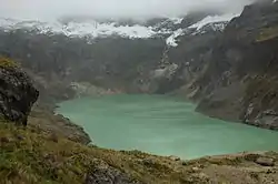
El Altar
El Altar or Capac Urcu (possibly from Kichwa kapak principal, great, important / magnificence, urku mountain)[3][4] is an extinct volcano on the western side of Sangay National Park in Ecuador, 170 km (110 mi) south of Quito, with a highest point of 5,319 m (17,451 ft). Spaniards named it so because it resembled two nuns and four friars listening to a bishop around a church altar. In older English sources it is also called The Altar.[5]
| El Altar | |
|---|---|
| Capak Urcu | |
 El Altar in 2006 | |
| Highest point | |
| Elevation | 5,319 m (17,451 ft) [1] |
| Prominence | 2,072 m (6,798 ft) [1] |
| Listing | Ultra List of volcanoes in Ecuador |
| Coordinates | 01°39′48″S 78°24′33″W [1] |
| Geography | |
 El Altar | |
| Parent range | Andes |
| Geology | |
| Age of rock | Pliocene-Pleistocene |
| Mountain type | Stratovolcano (extinct) |
| Last eruption | Unknown |
| Climbing | |
| First ascent | 7 July 1963 by Marino Tremonti, Ferdinando Gaspard and Claudio Zardini[2] |
| Easiest route | rock/ice climb |
Geology
El Altar consists of a large stratovolcano of Pliocene-Pleistocene age with a caldera breached to the west. Inca legends report that the top of El Altar collapsed after seven years of activity in about 1460, but the caldera is considered to be much older than this by geologists. Nine major peaks over 5,000 metres (16,400 ft) form a horseshoe-shaped ridge about 3 kilometres (1.9 mi) across, surrounding a central basin that contains a crater lake at about 4,200 m (13,800 ft), known as Laguna Collanes or Laguna Amarilla.

Access and recreation
El Altar is perhaps the most technically demanding climb in Ecuador. The route to the El Obispo summit is graded D+.[6] December through February are the best months to attempt an ascent. Much more accessible is the hike to the lake within the caldera of the mountain. From Riobamba, one takes a bus for about an hour to Candelaria and then checks in at the ranger station to enter the Sangay park. About 4–7 hours of an extremely muddy trail (knee-high rubber boots are recommended) leaves one at the refuge belonging to Hacienda Releche, which can be rented. The refuge has many beds, and a kitchen. To hike to the lake is another 1.5h - 2 hours from the refuge across a valley and up a steep hill.
List of peaks
The nine peaks of El Altar, starting with the highest summit on the south side and proceeding counterclockwise:
| Peak name | Translation | Elevation | Direction from lake | First ascent |
|---|---|---|---|---|
| Obispo | Bishop | 5,319 m (17,451 ft) | South | July 7, 1963, Ferdinando Gaspard, Marino Tremonti, Claudio Zardini |
| Monja Grande | Great Nun | 5,160 m (16,929 ft) | Southeast | August 17, 1968, Bill Ross and Margaret Young |
| Monja Chica | Small Nun | 5,080 m (16,667 ft) | East-Southeast | January 16, 1971, Peter Bednar and party |
| Tabernáculo | Tabernacle | 5,180 m (16,995 ft) | East | |
| Fraile Oriental | Eastern Friar | 5,060 m (16,601 ft) | East-Northeast | |
| Fraile Beato | Devout Friar | 5,050 m (16,568 ft) | East-Northeast | |
| Fraile Central | Central Friar | 5,070 m (16,634 ft) | Northeast | |
| Fraile Grande | Great Friar | 5,180 m (16,995 ft) | North-Northeast | December 1, 1972, Lorenzo Lorenzi, Armando Perron, Marino Tremonti |
| Canónigo | Canon | 5,260 m (17,257 ft) | North | March 7, 1965, Ferdinando Gaspard, Lorenzo Lorenzi, Marino Tremonti, Claudio Zardini |
See also
References
- "Ecuador: 15 Mountain Summits with Prominence of 1,500 meters or greater" Peaklist.org. Retrieved 2013-03-01.
- Neate, Jill. Mountaineering in the Andes: A Sourcebook for Climbers. Royal Geographical Society, 1994, p.26.
- Kichwa Yachakukkunapa Shimiyuk Kamu (Ministry of Education, Ecuador) (Kichwa-Spanish dictionary), 2009
- Miñaca Rea Silvia Patricia, Vallejo Lara Vicente Orlando, Diseño de paquetes turísticos para el Nevado Los Altares por el sector Inguisay, Universidad de Chimborazo, 2010 (in Spanish)
- The New International Encyclopaedia Volume 1 ed Frank Moore Colby, Talcott Williams 1918 Page 618 "The northern group, mainly comprised in Ecuador, is the most imposing collection of active and extinct volcanoes on earth. ... The Altar, a truncated mountain, 17,736 feet in height, is said to have once been the highest in the region"
- Comair, Chris (17 January 2018). "El Altar, The Modern Italian Route". Gethighonaltitude.com. Retrieved 26 March 2019.
Sources
- Brain, Yossi (2000). Ecuador: A Climbing Guide. Mountaineers Books. p. 192 pp. ISBN 0-89886-729-0.
- Hall, Minard L. (1977). El Volcanismo en el Ecuador. Sección Nacional del Ecuador. p. 120 pp. (in Spanish)
- Biggar, John (2005). The Andes: A Guide for Climbers (3rd ed.). Andes Publishing (Scotland). p. 304 pp. ISBN 0-9536087-2-7.
- Global Volcanism Program: Altar