Faulagh
Faulagh (Irish: Fálach) is a townland in Kilcommon, Erris, County Mayo, Ireland, some 946 acres (3.83 km2) in size. It's a remote spot on the main Ballycastle to Belmullet road. Faulagh and its neighbouring townland Muingerroon South are located on a mountain which skirts the townland of Bellanaboy where the contentious Corrib Gas terminal has been constructed over the last ten years. There is a small village cluster of houses and farms in Faulagh (the name means "Enclosures") along a small road branching off to the village of Knocknalower above Pollathomas, the main village in the parish. Muingerroon South townland is 1,454 acres (5.88 km2) in size—habitation is fairly sparse and the existing houses mainly form a linear pattern along the main road overlooking Carrowmore Lake.
Faulagh
Fálach | |
|---|---|
 Faulagh Location in Ireland | |
| Coordinates: 54°16′00″N 9°47′00″W | |
| Country | Ireland |
| Province | Connacht |
| County | County Mayo |
| Elevation | 00 m (0 ft) |
| Irish Grid Reference | F820374 |
Archaeology
Faulagh and its neighbouring townland Muingerroon have several ancient prehistoric sites on their blanket bog covered slopes. On the slopes of Faulagh and Muingerroon overlooking Carrowmore Lake, the drinking water supply for the greater Erris area, there are a number of megalithic tombs, many of them buried below the blanket bog but with many also still visible.
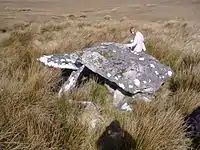
The southern slopes of the mountain must have been quite heavily populated during Neolithic and possibly also Bronze Age times. There has been little archaeological research carried out on the mountain but there are prehistoric field (agriculture) walls similar to those found further east at the much publicised Ceide Fields. The southern slopes have the remains of megalithic tombs of various types. Court tombs, wedge tombs and portal tombs have been identified and several other tombs and structures in the townland are listed as unclassified or as hut sites. On the northern slopes, facing Sruwaddacon Bay, there is an unclassified tomb known locally as The Grey Stone (see Gallery).[1]
One of the court tombs on the southern slopes appears to have three lots of concentric circles carved into the face of one of its stones, a fact not recorded or recognised in the National Monument (Ireland) register of archaeological sites (see Gallery).[2]
There are signs in the form of vertical ancient schist stone "kerb slabs", of an ancient way-marked "pathway" across several mountains in the western portion of Kilcommon townland. This "waymarked way may have run all the way to Glengad townland, Kilcommon from the Faulagh and Muingerroon area. Glengad is some nine kilometres to the north of Faulagh. Vertical stones set into the ground and now almost disappeared into the blanket bog are particularly obvious on a site in Graghil townland in the north of the Dún Chiortáin peninsula of Kilcommon (see Gallery) and await further investigation. Pictured is one of the marker stones in Faulagh which had all but disappeared under the bog and there are many signs of the trail across the intervening landscape for at least nine kilometres to Graghil townland on the Broadhaven Bay coast. Remnants of this way-marked trail are to be found from the townlands of Glengad, through Graghil and Gortbrack, through Knocknalower and across to Faulagh and Muingerroon, a trail running at a mid level up the mountainsides along which a myriad of suspected megalithic tombs and prehistoric stone circles are to be found also. Cnoc Nansai in particular has lots of cap stones (an isolated very large slab of rock, usually flattened in shape) at ground level which when one sticks their arm underneath, it can be felt and seen (using a torch) that there are orthostats and a hollow space or a water or mud filled space beneath the large flagstones.
Images
 The Grey Stone on the northern slopes of Faulagh Mountain
 Three groups of concentric circles are carved onto this rock, part of a court tomb on the southern slopes of Faulagh Mountain
 Half buried standing stone, part of way-marked way across mountains, Faulagh, Kilcommon, Erris.
.JPG.webp) Ancient way marked path as it appears in Graghil, Kilcommon, Erris.
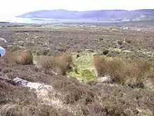
Ancient way marked path as it appears in Graghil, Kilcommon, Erris. View from the southern slopes of Faulagh towards Carrowmore Lake and pair of standing stones in mid ground
 A slightly different view of the rock art
 Another tomb on the Faulagh slopes
References
- Noone, Fr. Sean, Where the Sun Sets (1991) Naas
- MacGearraigh, Treasa. Comhar Dún Chaocháin Teo, Carrowteige, Papers and Reports (2008)