Fox House, South Yorkshire
Fox House is a hamlet in the Peak District, near the border between South Yorkshire and Derbyshire in northern England.[1][2] The area is situated on the A6187 road.[3] the Fox House Inn, A 17th-century Grade II-listed building, which lends its name to the hamlet, is located close to the Longshaw estate.[4][5]
| Fox House | |
|---|---|
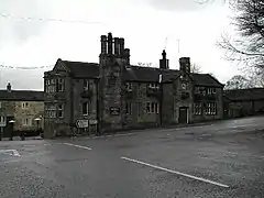 Fox House Public House | |
 Fox House Location within South Yorkshire | |
| OS grid reference | SK272805 |
| Metropolitan borough | |
| Metropolitan county | |
| Region | |
| Country | England |
| Sovereign state | United Kingdom |
| Post town | Sheffield |
| Postcode district | S11 |
| Dialling code | 01433 |
| Police | South Yorkshire |
| Fire | South Yorkshire |
| Ambulance | Yorkshire |
The inn was named for Mr Fox of Callow Farm in Highlow.
Nearby on Houndkirk Moor, a starfish site, an illuminated night-time decoy, was created during the Second World War to simulate Sheffield and divert German bomber attacks.[6]
References
- "Worldwide Elevation Finder". elevation.maplogs.com. Retrieved 24 November 2020.
- "Longshaw Estate Burbage Brook walk". National Trust. Retrieved 24 November 2020.
- Besley, Paul (30 March 2017). Dark Peak Walks: 40 walks exploring the Peak District gritstone and moorland landscapes. Cicerone Press Limited. ISBN 978-1-78362-464-5.
- "The Fox House Pub & Restaurant in Longshaw". Vintage Inns. Retrieved 24 November 2020.
- "Fox House pub, Longshaw - Sheffield Pub Guide". www.sheffieldpub.co.uk. Retrieved 24 November 2020.
- Historic England. "STARFISH BOMBING DECOY SF3C (1468517)". PastScape. Retrieved 4 December 2020.
This article is issued from Wikipedia. The text is licensed under Creative Commons - Attribution - Sharealike. Additional terms may apply for the media files.