Glendowie, New Zealand
Glendowie is a suburb in Auckland, New Zealand. It is under the local governance of Auckland Council. It was formerly under Auckland City Council from 1989 until the merger of all of Auckland's councils into the 'super city' in 2010.
Glendowie | |
|---|---|
Suburb | |

| |
| Country | New Zealand |
| Local authority | Auckland Council |
| Electoral ward | Ōrākei Ward |
| Population (2018) | |
| • Total | 8,832 |
| Saint Heliers | (Hauraki Gulf) | |
|
|
(Tamaki River) | |
| Glen Innes | Wai o Taiki Bay |
Location
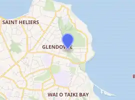
Glendowie is located on the north-eastern extent of the Auckland isthmus. Its northern and eastern boundaries are defined by the Waitematā Harbour and the Tamaki Estuary.
The suburbs exhibit an affluent suburban residential character.
Demographics
| Year | Pop. | ±% p.a. |
|---|---|---|
| 2006 | 7,971 | — |
| 2013 | 8,451 | +0.84% |
| 2018 | 8,832 | +0.89% |
| Source: [1] | ||

Glendowie, comprising the statistical areas of Glendowie North and Glendowie South, had a population of 8,832 at the 2018 New Zealand census, an increase of 381 people (4.5%) since the 2013 census, and an increase of 861 people (10.8%) since the 2006 census. There were 2,877 households. There were 4,359 males and 4,476 females, giving a sex ratio of 0.97 males per female, with 1,932 people (21.9%) aged under 15 years, 1,515 (17.2%) aged 15 to 29, 3,987 (45.1%) aged 30 to 64, and 1,398 (15.8%) aged 65 or older.
Ethnicities were 81.0% European/Pākehā, 4.8% Māori, 3.7% Pacific peoples, 15.0% Asian, and 3.6% other ethnicities (totals add to more than 100% since people could identify with multiple ethnicities).
The proportion of people born overseas was 36.2%, compared with 27.1% nationally.
Although some people objected to giving their religion, 44.6% had no religion, 44.4% were Christian, and 5.9% had other religions.
Of those at least 15 years old, 2,886 (41.8%) people had a bachelor or higher degree, and 576 (8.3%) people had no formal qualifications. The employment status of those at least 15 was that 3,324 (48.2%) people were employed full-time, 1,149 (16.7%) were part-time, and 204 (3.0%) were unemployed.[1]
History
Historically, the area of Glendowie around Taylors Hill was a forest of mostly puriri trees.[2] The eastern edge of Glendowie bordering the Tāmaki River was called Tauoma, and was the Eastern edge of the area settled by Te Ākitai Waiohua, the largest settlement of which was called Te Taurere (located at Taylors Hill).[2] Around 1750, Ngāti Whātua expanded their territory further into Tāmaki Makaurau, and gifted the land to Ngāti Pāoa in the late 1700s.[2][3]
The suburb of Glendowie was established in the 1920s, when George Riddell created a loop road through the area.[4] It takes its name from one of the much earlier Taylor Brothers' farm estates, Glen Dowie, owned by Richard James Taylor. Two of his brothers also had farms in this area and built houses; Charles John Taylor at Glen Orchard (now St. Heliers), and William Innes Taylor at Glen Innes (gave its name to the suburb Glen Innes).[5] Their brother Allen Kerr Taylor lived near Mount Albert in a house called Alberton.[6]
Education
Glendowie College is a secondary school (years 9-13) with a roll of 1261.[7]
Glendowie School, Churchill Park School, and Glen Taylor School are full primary schools (years 1-8) with rolls of 600, 429 and 241 students, respectively.[8][9][10]
Sacred Heart College is a state-integrated Catholic boys' school (years 7-13) with a roll of 1306.[11]
All these schools apart from Sacred Heart are coeducational. Rolls are as of March 2020.[12]
Sports Clubs
Glendowie has a tennis club, bowls club, and taekwondo club, all located adjacent to Churchill Park. The Eastern Suburbs soccer club and Bayside Westhaven baseball clubs hold matches at Crossfield Reserve.
Notable residents
- Sir Kenneth Myers (1907–1998), son of Arthur Myers and father of Sir Douglas Myers. He and his wife Margaret Pirie resided in a house designed for them by the architects Chilwell & Trevithick
- Graeme Hart, businessman[13]
- Don Brash, former NZ Leader of the Opposition (National Party 2003–2006)[14]
- Barry Colman, owner of National Business Review[14]
See also
- Delving into The Past Of Auckland's Eastern Suburbs; Section 6, St.Heliers, Elizabeth T. Jackson
References
- "Statistical area 1 dataset for 2018 Census". Statistics New Zealand. March 2020. Glendowie North (144000) and Glendowie South (145100). 2018 Census place summary: Glendowie North 2018 Census place summary: Glendowie South
- Leahy, Anne (1991). "EXCAVATIONS AT TAYLOR'S HILL, R11/96, AUCKLAND". Records of the Auckland Institute and Museum. 28: 33–68. ISSN 0067-0464.
|access-date=requires|url=(help) - Te Ākitai Waiohua (24 August 2010). "CULTURAL VALUES ASSESSMENT BY TE ĀKITAI WAIOHUA for MATUKUTŪREIA QUARRY PRIVATE PLAN CHANGE" (PDF). Auckland Council. Retrieved 4 February 2021.
- Cossar, Charlotte (14 June 2003). "Glendowie". The New Zealand Herald. Retrieved 8 April 2010.
- Stacpoole, John. "Allan Kerr Taylor". Dictionary of New Zealand Biography. Ministry for Culture and Heritage. Retrieved 25 January 2012.
- "Alberton". Heritage New Zealand – heritage.org.nz. Retrieved 9 April 2017.
- Education Counts: Glendowie College
- Education Counts: Glendowie School
- Education Counts: Churchill Park School
- Education Counts: Glen Taylor School
- Education Counts: Sacred Heart College
- "New Zealand Schools Directory". New Zealand Ministry of Education. Retrieved 26 April 2020.
- "Graeme Hart surpasses wealth of more famous peers". TV3. Retrieved 1 March 2009.
- Mandow, Nikki (July 2007). "Glendowie". Metro (312).
External links
- Photographs of Glendowie held in Auckland Libraries' heritage collections.