Grade I listed buildings in Cherwell (district)
There are over 9,000 Grade I listed buildings in England. This page is a list of these buildings in the district of Cherwell in Oxfordshire.
List of buildings
| Name | Location | Type | Completed [note 1] | Date designated | Grid ref.[note 2] Geo-coordinates |
Entry number [note 3] | Image |
|---|---|---|---|---|---|---|---|
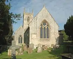
| Church of St Mary | Adderbury East, Adderbury | Church | Early 13th century | 8 December 1955 | SP4708935378 52°00′53″N 1°18′55″W |
1200012 | 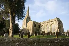 Church of St Mary |
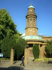
| Church of St Mary | Banbury | Church | c.1790 | 9 April 1952 | SP4540840551 52°03′41″N 1°20′21″W |
1369519 | |
| Church of St Michael | Barford St Michael | Church | c.1150 | 8 December 1955 | SP4327032610 51°59′25″N 1°22′17″W |
1284140 |  Church of St Michael |
| Church of St Edburg | Bicester | Church | 11th century | 31 January 1952 | SP5830222278 51°53′46″N 1°09′15″W |
1199769 |  Church of St Edburg |
| Church of St Mary | Bloxham | Church | 12th century | 8 December 1955 | SP4301135679 52°01′04″N 1°22′29″W |
1284130 |  Church of St Mary |
| Broughton Castle and attached walls | Broughton | Manor house | 14th century | 8 December 1955 | SP4180938173 52°02′25″N 1°23′31″W |
1248742 |  Broughton Castle and attached walls |
| Broughton Castle, gatehouse, bridge and curtain wall | Broughton | Gatehouse | 14th century | 8 December 1955 | SP4180438242 52°02′28″N 1°23′31″W |
1248762 |  Broughton Castle, gatehouse, bridge and curtain wall |
| Broughton Castle, stable block | Broughton | Stable | 15th century | 8 December 1955 | SP4184438246 52°02′28″N 1°23′29″W |
1277775 |  Broughton Castle, stable block |
| Church of St Mary the Virgin | Broughton | Church | c.1300 | 8 December 1955 | SP4186138321 52°02′30″N 1°23′28″W |
1248778 |  Church of St Mary the Virgin |
| Church of St Peter | Bucknell | Church | 11th/12th century | 7 December 1966 | SP5608425599 51°55′34″N 1°11′09″W |
1200258 |  Church of St Peter |
| Church of St Mary the Virgin | Charlton-on-Otmoor | Church | 13th and 14th century | 7 December 1966 | SP5619415815 51°50′17″N 1°11′09″W |
1370086 |  Church of St Mary the Virgin |
| Old Manor Farmhouse | Cottisford | Farmhouse | 13th/14th century | 26 November 1951 | SP5892231082 51°58′30″N 1°08′37″W |
1046440 |  |
| Church of St Mary the Virgin | Cropredy | Church | 13th century | 8 December 1955 | SP4689946668 52°06′59″N 1°18′59″W |
1216164 |  Church of St Mary the Virgin |
| The Leadenporch House | Deddington | Farmhouse | Early 14th century | 8 December 1955 | SP4668031405 51°58′45″N 1°19′18″W |
1300760 |  The Leadenporch House |
| Chapel at Water Eaton Manor House | Water Eaton | Domestic chapel | c.1600 | 7 December 1966 | SP5156712104 51°48′19″N 1°15′13″W |
1046563 |  Chapel at Water Eaton Manor House |
| Church of St Peter | Hanwell | Church | 13th century | 8 December 1955 | SP4357243575 52°05′20″N 1°21′56″W |
1216364 |  Church of St Peter |
| Church of St Peter | Hook Norton | Church | 12th century[1] | 8 December 1955 | SP3551233125 51°59′44″N 1°29′03″W |
1369840 |  Church of St Peter |
| Church of St Ethelreda | Horley | Church | 12th century | 8 December 1955 | SP4168543965 52°05′33″N 1°23′35″W |
1216504 |  Church of St Ethelreda |
| Church of St John the Baptist | Hornton | Church | 12th century | 8 December 1955 | SP3922245005 52°06′07″N 1°25′44″W |
1227940 |  Church of St John the Baptist |
| Church of St Nicholas | Islip | Church | 11th century | 7 December 1966 | SP5265214095 51°49′23″N 1°14′15″W |
1046574 | |
| Church of St Mary | Kidlington | Church | 12th century | 7 December 1966 | SP4972314809 51°49′47″N 1°16′48″W |
1291046 |  Church of St Mary |
| Kirtlington Park | Kirtlington | Country house | 1742–46 | 26 November 1951 | SP5082219833 51°52′29″N 1°15′47″W |
1200202 | |
| Church of the Assumption of the Blessed Virgin Mary | Launton | Church | Late 12th century | 7 December 1966 | SP6043822827 51°54′03″N 1°07′23″W |
1369735 |  Church of the Assumption of the Blessed Virgin Mary |
| Church of St Swithun | Merton | Church | 13th century | 7 December 1966 | SP5773717816 51°51′21″N 1°09′47″W |
1369750 |  Church of St Swithun |
| Middleton Park | Middleton Stoney | Country house | 1938 | 26 November 1951 | SP5249223237 51°54′19″N 1°14′18″W |
1232948 | |
| Church of St Michael and All Angels | Alkerton | Church | c.1200 | 8 December 1955 | SP3772142924 52°05′00″N 1°27′03″W |
1300845 |  Church of St Michael and All Angels |
| Church of St James | Somerton | Church | 12th century | 7 December 1966 | SP4968828631 51°57′14″N 1°16′42″W |
1225707 |  Church of St James |
| Churchyard cross approximately 12 metres north of church of St James | Somerton | Cross | Medieval | 26 February 1988 | SP4970428645 51°57′15″N 1°16′41″W |
1225734 | 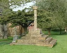 Churchyard cross approximately 12 metres north of church of St James |
| Church of St Peter ad Vincula | South Newington | Church | 12th century | 8 December 1955 | SP4074733338 51°59′49″N 1°24′29″W |
1277633 | 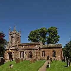 Church of St Peter ad Vincula |
| Church of St Mary and St Edburga | Stratton Audley | Church | 14th and 15th century | 7 December 1966 | SP6085826036 51°55′46″N 1°06′59″W |
1046404 |  Church of St Mary and St Edburga |
| Church of St Peter and St Paul | Swalcliffe | Church | Saxon | 8 December 1955 | SP3785737892 52°02′17″N 1°26′58″W |
1199016 | 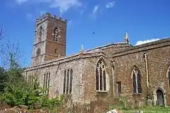 Church of St Peter and St Paul |
| Manor House | Swalcliffe | Hall house | 13th century | 8 December 1955 | SP3780537905 52°02′18″N 1°27′01″W |
1046268 | |
| Tithe Barn | Swalcliffe | Tithe barn | c.1400 | 8 December 1955 | SP3774537919 52°02′18″N 1°27′04″W |
1046267 | 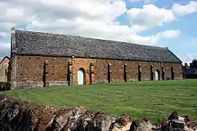 Tithe Barn |
| Church of St Nicholas | Tadmarton | Church | 12th century | 8 December 1955 | SP3923837856 52°02′16″N 1°25′46″W |
1369852 |  Church of St Nicholas |
| Tithe Barn approximately 30 metres south of Manor Farmhouse | Upper Heyford | Tithe barn | c.1400 | 26 November 1951 | SP4944425812 51°55′43″N 1°16′56″W |
1266058 |  Tithe Barn approximately 30 metres south of Manor Farmhouse |
| Church of St Mary Magdalene | Wardington | Church | 12th century | 8 December 1955 | SP4911246334 52°06′47″N 1°17′03″W |
1228671 |  Church of St Mary Magdalene |
| Church of Saint Giles | Wigginton | Church | 13th century | 8 December 1955 | SP3907733282 51°59′48″N 1°25′56″W |
1052175 |  Church of Saint Giles |
| Wroxton College and attached walls and steps | Wroxton | Country house | c.1618 | 8 December 1955 | SP4166141622 52°04′17″N 1°23′37″W |
1046769 |  Wroxton College and attached walls and steps |
| Church of St Bartholomew | Yarnton | Church | 12th century | 7 December 1966 | SP4776711676 51°48′06″N 1°18′31″W |
1290230 |  Church of St Bartholomew |
See also
Notes
- The date given is the date used by Historic England as significant for the initial building or that of an important part in the structure's description.
- Sometimes known as OSGB36, the grid reference is based on the British national grid reference system used by the Ordnance Survey.
- The "List Entry Number" is a unique number assigned to each listed building and scheduled monument by Historic England.
References
- "History of St Peter's Church". St Peter's Church, Hook Norton. Retrieved 6 March 2014.
External links
![]() Media related to Grade I listed buildings in Oxfordshire at Wikimedia Commons
Media related to Grade I listed buildings in Oxfordshire at Wikimedia Commons
This article is issued from Wikipedia. The text is licensed under Creative Commons - Attribution - Sharealike. Additional terms may apply for the media files.