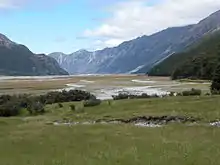
Hopkins River (New Zealand)
The Hopkins River is in the central South Island of New Zealand.[1] It flows south for 40 kilometres (25 mi) from the Southern Alps into the northern end of Lake Ohau in the Mackenzie Country.[2]

Hopkins River, New Zealand
Its headwaters, on the southern slopes of Mount Hopkins, form the northernmost point of Otago, and the river's braided valley is part of the border between Otago and Canterbury.[3][4][5] The river's main tributary is the Dobson River.[6]
References
- "New Zealand Topographic Map". NZ Topo Map. Retrieved 19 January 2021.
- "Lake Ohau Water Quality". Land, Air, Water Aotearoa (LAWA). Retrieved 19 January 2021.
- Rae, Sally (22 November 2008). "Celebration to mark boundary squabble". Otago Daily Times. Retrieved 19 January 2021.
- "Boundary dispute remembered". Stuff. 31 January 2009. Retrieved 19 January 2021.
- "Lake Ohau, South Island, New Zealand". Lakelubbers. 2021. Retrieved 19 January 2021.
- "Lake Ohau". nzfishing.com. Retrieved 19 January 2021.
This article is issued from Wikipedia. The text is licensed under Creative Commons - Attribution - Sharealike. Additional terms may apply for the media files.