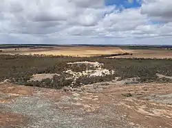
Hyden Humps Dam
Hyden Humps Dam is situated at the southern base of The Humps, approximately seventeen kilometres (11 miles) north east of Hyden and fifteen kilometres (9.3 miles) north of Wave Rock.[1][2]
Water

The Hyden Humps Dam, seen from The Humps in 2020
The dam is filled with rainwater runoff which is channeled off the Humps mountain.[3]
Characteristics
The water source is now only used as a backup supply after the completion of the Great Southern scheme where water is piped through the wheatbelt region from the Harris River Dam.
See also
- List of reservoirs and dams in Australia
References
- Twidale, C R; Bourne, J A (September 2004). "Notes on the Geomorphology of the Humps, Near Hyden, Western Australia" (PDF). Journal of the Royal Society of Western Australia. 87 (3): 123–133. Retrieved 22 August 2018.
- Gunn, R. G. (2006). "Mulka's Cave Aboriginal Rock Art Site: Its Context and Content" (PDF). Records of the Western Australian Museum. 23: 19–41. Retrieved 22 August 2018.
- "Hyden Rock Dam – Heritage Council of WA – Places Database". Heritage Council, Government of Western Australia. 1 January 2017. Retrieved 23 August 2018.
Bibliography
- Serventy, Vincent. Article on The Humps, a rock formation near Hyden W.A. Naturalist Vol. 3, No. 6, 1952. also at Research Note 552 - Battye Library.
External links
- The dam site can be seen on this map. Google Maps
- Dam storage level
This article is issued from Wikipedia. The text is licensed under Creative Commons - Attribution - Sharealike. Additional terms may apply for the media files.