Iowa Highway 96
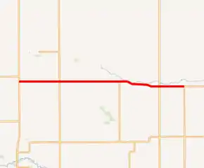
Iowa Highway 96 (Iowa 96) is a state highway which runs from west to east in central Iowa. It begins at Iowa Highway 14 southwest of Conrad and ends at U.S. Highway 63 east of Gladbrook.
| ||||
|---|---|---|---|---|

Iowa 96 highlighted in red | ||||
| Route information | ||||
| Maintained by Iowa DOT | ||||
| Length | 16.635 mi[1] (26.771 km) | |||
| Major junctions | ||||
| West end | ||||
| East end | ||||
| Location | ||||
| Counties | Marshall, Tama | |||
| Highway system | ||||
| ||||
Route description
Iowa Highway 96 begins at a T-intersection with Iowa Highway 14 3 miles (4.8 km) southwest of Conrad. From Iowa 14, it heads due east for 10 miles (16 km) towards Gladbrook. East of Gladbrook, it continues east, angling slightly to the southeast, for 6 miles (9.7 km) until it ends at another T-intersection with U.S. Highway 63.[1]
History
Primary Road No. 96 was originally designated as a 6-mile-long (9.7 km), unpaved spur route connecting Gladbrook to Primary Road No. 59 southwest of Traer. In 1926, Highway 59 became U.S. Highway 63.[2] By 1947, the highway had been extended west to Iowa 14.[3] By 1956, the entire route was paved.[4]
Major intersections
| County | Location | mi[1] | km | Destinations | Notes |
|---|---|---|---|---|---|
| Marshall | Liscomb Township | 0.000 | 0.000 | ||
| Tama | Crystal Township | 16.635 | 26.771 | ||
| 1.000 mi = 1.609 km; 1.000 km = 0.621 mi | |||||
References
- 2009 Volume of Traffic on the Primary Road System of Iowa (PDF) (Report). Iowa Department of Transportation. January 1, 2009. Retrieved August 16, 2010.
- Junior Road Map: Eastern Iowa (Map). Rand McNally & Company. 1926. Retrieved August 16, 2010.
- Road and Reference Atlas (Map). 1:1,077,120. Rand McNally & Company. 1947. pp. 42–43.
- Iowa State Highway Map (PDF) (Map). Iowa State Highway Commission. 1956. Retrieved August 16, 2010.
