Kirklees Way
The Kirklees Way is a 72-mile (115 km) waymarked footpath in Kirklees metropolitan district, West Yorkshire, England. It was opened in 1990 and includes the upper Colne Valley, Spen Valley and Holme Valley.
| Kirklees Way | |
|---|---|
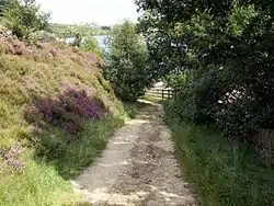
 Kirklees Way near Digley Reservoir | |
| Length | 72 mi (116 km) |
| Location | West Yorkshire, England |
| Trailheads | circular |
| Use | Hiking |
| Hiking details | |
| Season | All year |
The Peak District Boundary Walk follows the Kirklees Way for a few miles either side of Holme.[1]
References
- McCloy, Andrew (2017). Peak District Boundary Walk: 190 Miles Around the Edge of the National Park. Friends of the Peak District. ISBN 978-1909461536.
Further reading
- Patrick, Nigel; Williamson, Peter. Walk the Kirklees Way. Kirklees Council. ISBN 0-903603-33-0.
This article is issued from Wikipedia. The text is licensed under Creative Commons - Attribution - Sharealike. Additional terms may apply for the media files.