Lesotho Highlands Water Project
The Lesotho Highlands Water Project (LHWP) is an ongoing water supply project with a hydropower component, developed in partnership between the governments of Lesotho and South Africa. It comprises a system of several large dams and tunnels throughout Lesotho and delivers water to the Vaal River System in South Africa. In Lesotho, it involves the rivers Malibamatso, Matsoku, Senqunyane, and Senqu. It is Africa's largest water transfer scheme.


The purpose of the project is to provide Lesotho with a source of revenue in exchange for the provision of water to South Africa, as well as generate hydroelectricity for Lesotho.[1]
History
Efforts to create a dam in the location were spearheaded by then British High Commissioner Sir Evelyn Baring in the 1950s. After a feasibility study was conducted between August 1983 and August 1986 (German-British Lahmeyer MacDonald Consortium was appointed for this task), the project eventually began to be realized.
The project has also been alleged to have had negative social and environmental effects. While compensation was provided in kind and paid to the few hundred households affected by the dams, there is criticism that it was insufficient.[2] It was not intended to address the water supply problems in Lesotho, but by paying royalties to the Lesotho Government for development purposes benefits have reached much of the population.
In recent years, water from the scheme has been discharged into the Mohokare (Caledon) river to provide water to Maseru in times of critical shortages. The new dams have filled as anticipated and discharge of water from the dams into the downstream rivers continues in a scheme devised to preserve ecological balances. This discharged water flows to the Senqu (Orange) and while preserving the ecological status quo benefits only those communities along the rivers.
The project has had an important impact on Lesotho's infrastructure, as hundreds of kilometers of engineered paved roads were built in order to improve access to the different construction sites, and, together with engineered unpaved 'feeder' roads around the dams, continue to provide much improved communication for many villages in the mountainous interior.
Since its inception, the project has been dogged by corruption which has resulted in a number of court cases involving both individuals and multinational corporations. [3]
Project features
Below is an overview of the main features of the first three phases of the project.
| Phase IA | Phase IB | Phase II | Phase III | |
|---|---|---|---|---|
| Name | Katse Dam | Mohale Dam | Polihali Dam[4] | Tsoelike Dam |
| Dam height (m) | 185 | 145 | 163.5 | 155 |
| Power generation[lower-alpha 1] (MW)
(installed capacity) |
110 | N/A | 3-8 (potentially)[5] | N/A |
| Water transfer capacity[lower-alpha 1] (m³/s) | 16.9 | 10.1 | 28.0 | 8.6 |
| Transfer tunnels | Yes | Yes | Yes | No |
| Delivery tunnels | Yes | No | No | No |
| Completed | Yes | Yes | Under Construction | No (On hold) |
- The values are estimates based on the feasibility study, and may differ from the current or eventual values, respectively.
Phase I
Phase of the project comprises all the essential components to impound water in the Katse Dam, generate electricity and deliver water to the Vaal River System. Phase I has been carefully configured so that Katse Dam remains the common link to further phases identified during feasibility studies. In line with the phased approach, Phase I consists of Phase IA comprising the essential components, and Phase IB which enhances the yield of the project with the addition of two peripheral sources namely the Mohale Dam and the Matsoku Weir.
Phase IA
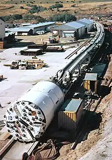
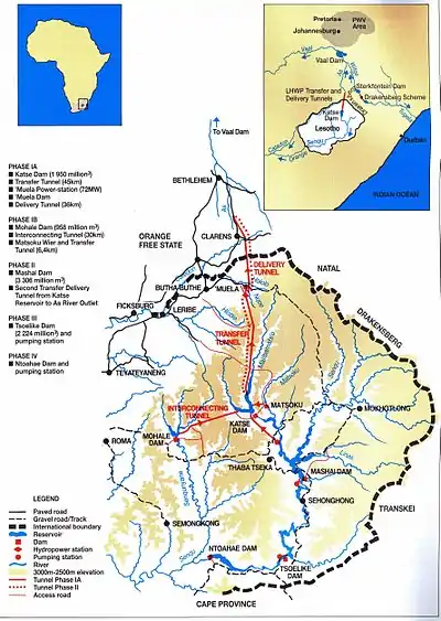
This phase of the project was completed in 1998. It consisted mainly of the construction of the Katse Dam on the Malibamat'so River in Lesotho. A 45-kilometre (28 mi) transfer tunnel was built from the Katse Dam to the Muela Reservoir. The Muela Reservoir is considered to be the tail pond, which supplies hydroelectric power for Lesotho. Stemming from the Muela Reservoir is a 37-kilometre (23 mi) delivery tunnel to the outfall at the As River from where water flows to the Vaal Dam. Although the Katse Dam has power generation capability for local use, the primary purpose is as the storage reservoir for Phase IA, and to provide discharge into the transfer tunnel.
To mitigate loss of habitat, the Katse Botanical Gardens was established to house plants that were rescued from the area to be flooded.[6]
Phase IB

This phase of the project was completed in 2002. It consisted mainly of the construction of:
- The Mohale Dam, a very large rockfill dam, located on the Senqunyane River;
- A 32-kilometre (20 mi) transfer tunnel between the Mohale Dam and the Katse Dam;
- Construction of the Matsoku Diversion Weir;
- A 5.7-kilometre (3.5 mi) tunnel from the Matsoku Diversion Weir to the Katse Dam.
The system is interconnected in such a way that water may be transferred in either direction for storage in Mohale or ultimate transfer to South Africa through the Katse reservoir.
Phase II
- In 2005, an agreement between the Governments of South Africa and Lesotho was signed to proceed with feasibility studies;
- In 2006, the feasibility study was commenced and completed in late 2008;
- The agreement to implement Phase II was signed in Maseru on 11 August 2011;
- The launch of Phase II construction took place at Tlokoeng on 27 March 2014.[7]
Later phases
As initially conceived, three further dams were proposed further downstream after the Malibamatso joins the Senqu river, at Mashai, Tsoelike, and Ntoahae.
In 2007, further studies resulted in a modification, proposing instead a dam on the Senqu upstream from the confluence with the Malibamatso. This is currently the preferred extension of the scheme, although construction has not yet begun (as of December 2007).
163.5-m-high
LHWP implementing body Lesotho Highlands Development Authority (LHDA) CEO Refiloe Tlali says:
‘……the 2.3-billion cubic metre Polihali dam will be built downstream of the confluence of the Senqu and Khubelu rivers. The dam will have a 163.5-m-high concrete-faced rockfill embankment dam wall. The crest length will be 915 m, with a full supply level of 2 075 m above sea level. A 49.5-m-high saddle dam and spillway will also be built…
This entailed the construction of more than 1 300 beacons to mark the 230 km perimeter of the reservoir.
See also
References
- "Home | LHDA". www.lhda.org.ls. Retrieved 2020-11-24.
- Hoover, Ryan (2001). Pipe Dreams - The World Bank’s Failed Efforts to Restore Lives and Livelihoods of Dam-Affected People in Lesotho (PDF) (Report). International Rivers Network. Archived from the original (PDF) on 19 August 2007.
- Earle, Anton; Turton, Anthony (2005). Corruption on the Lesotho Highlands Water Project - a case study (PDF). World Water Week 2005. Stockholm: Stockholm International Water Institute. Archived from the original (PDF) on 28 September 2007.
- "LHWP Phase II - Engineering". Lesotho Highlands Development Authority. 2015. Retrieved 1 October 2015.
- "LHWP Phase II - Engineering". Lesotho Highlands Development Authority. 2015. Retrieved 1 October 2015.
- "Katse Botanic Garden". Botanic Gardens Conservation International. Retrieved 9 December 2016.
- "LHWP Phase II - Milestones". Lesotho Highlands Development Authority. 2015. Retrieved 1 October 2015.
External links
- Lesotho Highlands Development Authority
- Trans Caledon Tunnel Authority
- Lesotho Highlands Further Phases Feasibility Study
- Aicha Amouchi
- Ryan Anton
- Hoover van Ryij