List of airports in the Netherlands Antilles
This is a list of airports in the former Netherlands Antilles upon its dissolution in 2010, sorted by location.
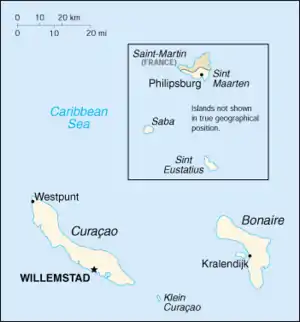
The Netherlands Antilles were part of the Lesser Antilles and consisted of two groups of islands in the Caribbean Sea: Bonaire and Curaçao (off the Venezuelan coast), and Saba, Sint Eustatius and Sint Maarten (located southeast of the Virgin Islands). The islands formed an autonomous part of the Kingdom of the Netherlands until the dissolution of the Netherlands Antilles in 2010.
List
| Island (City) | ICAO | IATA | Airport name | Coordinates |
| Bonaire (Kralendijk) | TNCB[1] | BON[2] | Flamingo International Airport | 12°07′51″N 068°16′06″W |
| Curaçao (Willemstad) | TNCC[3] | CUR[4] | Hato International Airport | 12°11′19″N 068°57′35″W |
| Saba | TNCS[5] | SAB[6] | Juancho E. Yrausquin Airport | 17°38′43″N 063°13′14″W |
| Sint Eustatius | TNCE[7] | EUX[8] | F.D. Roosevelt Airport | 17°29′47″N 062°58′45″W |
| Sint Maarten (Philipsburg) | TNCM[9] | SXM[10] | Princess Juliana International Airport | 18°02′27″N 063°06′32″W |
See also
- List of airports by ICAO code: T#Netherlands Antilles
- List of airports in Aruba (part of the Netherlands Antilles until 1986)
- Transportation in the Netherlands Antilles
- Wikipedia: WikiProject Aviation/Airline destination lists: North America#Netherlands Antilles
- List of airports in Bonaire
- List of airports in Saba
- List of airports in Sint Eustatius
References

Map of the Netherlands Antilles.
- Sources
- "UN Location Codes: Netherlands Antilles] [includes IATA codes". UN/LOCODE 2006-2. UNECE. 2007-04-30.
- Notes
- Airport information for TNCB at World Aero Data. Data current as of October 2006.Source: DAFIF.
- Airport information for BON at Great Circle Mapper. Source: DAFIF (effective October 2006).
Accident history for BON at Aviation Safety Network - Airport information for TNCC at World Aero Data. Data current as of October 2006.Source: DAFIF.
- Airport information for CUR at Great Circle Mapper. Source: DAFIF (effective October 2006).
Accident history for CUR at Aviation Safety Network - Airport information for TNCS/SAB at Great Circle Mapper. Source: DAFIF (effective October 2006).
- Accident history for SAB at Aviation Safety Network
- Airport information for TNCE at World Aero Data. Data current as of October 2006.Source: DAFIF.
- Airport information for EUX at Great Circle Mapper. Source: DAFIF (effective October 2006).
Accident history for EUX at Aviation Safety Network - Airport information for TNCM at World Aero Data. Data current as of October 2006.Source: DAFIF.
- Airport information for SXM at Great Circle Mapper. Source: DAFIF (effective October 2006).
Accident history for SXM at Aviation Safety Network
External links
- Lists of airports in the Netherlands Antilles:
This article is issued from Wikipedia. The text is licensed under Creative Commons - Attribution - Sharealike. Additional terms may apply for the media files.
.svg.png.webp)