Lithospheric flexure
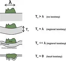
The lithospheric flexure (also called regional isostasy) is the process by which the lithosphere (rigid outer layer of the Earth) bends under the action of forces such as the weight of a growing orogen or changes in ice thickness related to (de)glaciations. The lithosphere is the thin, outer, rigid layer of the Earth resting on the asthenosphere, a viscous layer that in geological time scales behaves as a fluid. Thus, when loaded, the lithosphere progressively reaches an isostatic equilibrium, which is the name of the Archimedes principle applied to these geological settings.[1]

This phenomenon was first described in the late 19th century to explain the shorelines uplifted in Scandinavia due to the removal of large ice massed during the last glaciation. G. K. Gilbert used it to explain the uplifted shorelines of Lake Bonneville.[2] The concept was not retaken until the 1950s by Vening Meinesz.
The geometry of the lithospheric bending is often modeled adopting a pure elastic thin plate approach (sometimes by fitting the gravity anomaly produced by that bending rather than more direct data of it). The thickness of such plate that best fits the observed lithospheric bending is called the equivalent elastic thickness of the lithosphere, and is related to the stiffness or rigidity of the lithosphere. These lithospheric bending calculations are typically performed following the Euler-Bernoulli bending formulation, or alternatively the Lagrange equation (Love-Kirchhoff).
References
- Watts, Anthony Brian (2001). Isostasy and Flexure of the Lithosphere. Cambridge, UK: Cambridge University Press. doi:10.2277/0521006007. ISBN 9780521006002.
- "Lake Bonneville" US Geological Survey Monograph No. 1. 1890. 438 p.