Lochloosa Creek
Lochloosa Creek is a stream that flows from north to south through eastern Alachua County, Florida.[1] Its watershed composed of 42.7 square miles through natural and Silvicultural land use. It is the largest tributary to Lochloosa Lake. Lochloosa Creek is longest creek in Alachua County.
| Lochloosa Creek | |
|---|---|
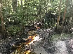 Lochloosa Creek, April 2019 | |
| Location | |
| Country | United States |
| State | Florida |
| County | Alachua County |
| Physical characteristics | |
| Source | |
| • location | Saluda Swamp |
| • coordinates | 29°39′56″N 82°09′35″W |
| Mouth | |
• location | Lochloosa Lake |
• coordinates | 29°32′54″N 82°08′16″W |
• elevation | 56 ft (17 m) |
| Basin size | 42.7 sq mi (111 km2) |
| Basin features | |
| GNIS | 285900 |
Headwaters
Forming from the Saluda Swamp, Lochloosa Creek begins as a small trickle of a stream that flows south. It flows through agricultural lands.
References
- "Lochloosa Creek". Geographic Names Information System. United States Geological Survey. Retrieved May 8, 2014.
This article is issued from Wikipedia. The text is licensed under Creative Commons - Attribution - Sharealike. Additional terms may apply for the media files.