Menguante Cove
Menguante Cove is a 1.47 km wide embayment indenting for 1.22 km the east coast of the horseshoe-shaped Half Moon Island in the South Shetland Islands, Antarctica. The area was visited by early 19th century sealers operating from nearby Yankee Harbour, and later by whalers; a whaling dory lies on the main landing beach on the southeast coast of the cove.[1] Nowadays Menguante Cove is frequented by Antarctic cruise ships.


The Argentine Antarctic base Cámara is situated at the cove's head.[1]
Location
The cove's midpoint is located at 62°35′28″S 59°54′20″W which is 5.51 km west-northwest of Renier Point, 4.7 km northeast of Rila Point, 7.89 km southeast of Edinburgh Hill, 8.32 km south-southwest of Triangle Point and 10.25 km west-southwest of Ephraim Bluff (British mapping in 1822 and 1968, Chilean in 1971, Argentine in 1980 and 2000, and Bulgarian in 2005 and 2009).
Maps
- Chart of South Shetland including Coronation Island, &c. from the exploration of the sloop Dove in the years 1821 and 1822 by George Powell Commander of the same. Scale ca. 1:200000. London: Laurie, 1822.
- L.L. Ivanov et al. Antarctica: Livingston Island and Greenwich Island, South Shetland Islands. Scale 1:100000 topographic map. Sofia: Antarctic Place-names Commission of Bulgaria, 2005.
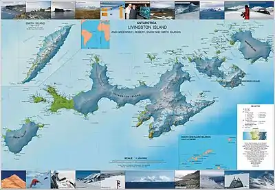
- L.L. Ivanov. Antarctica: Livingston Island and Greenwich, Robert, Snow and Smith Islands. Scale 1:120000 topographic map. Troyan: Manfred Wörner Foundation, 2009. ISBN 978-954-92032-6-4
Notes
- Half Moon Island. Visitor Site Guidelines. Secretariat of the Anarctic Treaty
References
- Half Moon Island. Visitor Site Guidelines. Secretariat of the Anarctic Treaty
- Cesar Garcia Esponda, Nestor Coria & Diego Montalti. Breeding birds at Half Moon Island, South Shetland Islands, Antarctica, 1995/96. Marine Ornithology, 2000, 28, pp. 59–62