Merced (district)
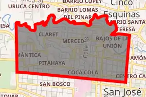
Merced is a district of the San José canton, in the San José province of Costa Rica.[1][2] It is one of the four administrative units that form San José downtown (casco central) properly. This division is merely commercial, but covers an important part of "josefino" life and activities.
Merced | |
|---|---|

Merced district | |
 Merced Merced district location in Costa Rica | |
| Coordinates: 9.9399591°N 84.0883582°W | |
| Country | |
| Province | San José |
| Canton | San José |
| Area | |
| • Total | 2.17 km2 (0.84 sq mi) |
| Elevation | 1,154 m (3,786 ft) |
| Population (2011) | |
| • Total | 12,257 |
| • Density | 5,600/km2 (15,000/sq mi) |
| Time zone | UTC−06:00 |
| Postal code | 10102 |
Geography
Merced has an area of 2.17 km²[3] and an elevation of 1154 metres.[1]
Merced lies in the north of the canton, limiting only with Tibás Canton from San José Province to the north, and with the districts of Uruca to the north, Mata Redonda to the west, Hospital to the south, and Uruca and El Carmen districts to the east, all of them from the same canton of San José.[4]
Locations
This district comprehend several "barrios" or neighbourhoods, like Bajos de la Unión, Claret, Coca-Cola, Iglesias Flores, Mantica, Barrio México, Paso de la Vaca y Pitahaya. In the territory there are many banks, public institutions and popular markets. Its main landmark is the Costa Rican Center of Science and Culture, one of the main institutions of Costa Rican culture. The neighborhoods are full of history and some of them are known for received several immigrants from all over the world during different decades. By the early 1950s a lot of members of the Jewish and Asian communities were established around Paseo Colón near Barrio La Pitahaya and Mantica, this changed drastically after moving San José Synagogue to the West Area of the city (Escazú). Nowadays the zone is populated by Costa Ricans, Nicaraguans, Colombians, Venezuelans, Americans, Italians and Dominicans. Making La Pitahaya one of the most diverse neighborhood in SJO. Barrio Mexico and Barrio Claret has being the first stop in San José for thousands for limonenses since the early 1960s.
Demographics
| Historical population | |||
|---|---|---|---|
| Census | Pop. | %± | |
| 1883 | 3,444 | — | |
| 1892 | 5,257 | 52.6% | |
| 1927 | 9,645 | 83.5% | |
| 1950 | 18,920 | 96.2% | |
| 1963 | 22,064 | 16.6% | |
| 1973 | 19,938 | −9.6% | |
| 1984 | 15,363 | −22.9% | |
| 2000 | 13,565 | −11.7% | |
| 2011 | 12,257 | −9.6% | |
|
Instituto Nacional de Estadística y Censos[5] |
|||
For the 2011 census, Merced had a population of 12257 inhabitants. [7]
Transportation
Road transportation
The district is covered by the following road routes:
External links
- Municipalidad de San José. Distrito Merced – Website of San Jose Mayor, includes a map of the district and related info.
References
- "Declara oficial para efectos administrativos, la aprobación de la División Territorial Administrativa de la República N°41548-MGP". Sistema Costarricense de Información Jurídica (in Spanish). 19 March 2019. Retrieved 26 September 2020.
- División Territorial Administrativa de la República de Costa Rica (PDF) (in Spanish). Editorial Digital de la Imprenta Nacional. 8 March 2017. ISBN 978-9977-58-477-5.
- "Área en kilómetros cuadrados, según provincia, cantón y distrito administrativo". Instituto Nacional de Estadística y Censos (in Spanish). Retrieved 26 September 2020.
- Mapa Cantonal del Censo de 1984, published by the National Institute of Statistics and Census(INEC) and updated by the Central American Population Center (CCP)
- "Instituto Nacional de Estadística y Censos" (in Spanish).
- "Sistema de Consulta de a Bases de Datos Estadísticas". Centro Centroamericano de Población (in Spanish).
- "Censo. 2011. Población total por zona y sexo, según provincia, cantón y distrito". Instituto Nacional de Estadística y Censos (in Spanish). Retrieved 26 September 2020.