Minnesota State Highway 263
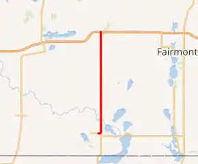
Minnesota State Highway 263 (MN 263) is a 11.226-mile-long (18.066 km) highway in southwest Minnesota, which runs from its intersection with Martin County State-Aid Highway 8 in Ceylon and continues north to its northern terminus at its interchange with Interstate 90 near Welcome, nine miles west of Fairmont.
| ||||
|---|---|---|---|---|

MN 263 highlighted in red | ||||
| Route information | ||||
| Defined by MS § 161.115(194) | ||||
| Maintained by MnDOT | ||||
| Length | 11.226 mi (18.066 km) | |||
| Existed | July 1, 1949[1]–present | |||
| Major junctions | ||||
| South end | ||||
| North end | ||||
| Location | ||||
| Counties | Martin | |||
| Highway system | ||||
| ||||
Route description
Highway 263 serves as a north–south connector route in southwest Minnesota between Ceylon and Interstate 90 near Welcome.
Highway 263 is also known as Main Street in Ceylon. The route follows Guide Street in Welcome.
History
Highway 263 was authorized on July 1, 1949.[1]
The route was paved in 1951.[2][3]
The highway will be resurfaced in 2021, and the highway will eventually will be turned back by 2023.[4][5]
Major intersections
The entire route is in Martin County.
| Location | mi | km | Destinations | Notes | |
|---|---|---|---|---|---|
| Ceylon | 0.000 | 0.000 | CR 8 west (Main Street), CR 125 north (Clark Street) | ||
| 0.213 | 0.343 | CR 6 (Railroad Street) | |||
| Lake Belt Township | 1.080 | 1.738 | CR 8 east | ||
| Tenhassen Township | 3.697 | 5.950 | CR 14 | ||
| Manyaska Township | 6.194 | 9.968 | CR 22 west | ||
| Rolling Green Township | 6.692 | 10.770 | CR 22 east | ||
| Welcome | 9.695 | 15.603 | CR 26 (120th Street) | Old U.S. 16 | |
| Fox Lake–Fraser township line | 11.094– 11.233 | 17.854– 18.078 | Interchange | ||
| 1.000 mi = 1.609 km; 1.000 km = 0.621 mi | |||||
References
- "Chapter 663-H.F. No. 1792", Session Laws of Minnesota for 1949, Earl L. Berg, Commissioner of Administration, pp. 1177–1185
- 1951 Official Road Map of Minnesota (Map). Cartography by The H.M. Gousha Company. Minnesota Department of Highways. January 1, 1951. § G20. Archived from the original on August 25, 2011. Retrieved January 20, 2011.
- 1952 Official Road Map of Minnesota (Map). Cartography by The H.M. Gousha Company. Minnesota Department of Highways. January 1, 1952. § G20. Archived from the original on July 21, 2011. Retrieved January 20, 2011.
- https://www.dot.state.mn.us/d7/newsrels/2019/09/04-hwy263.html. Missing or empty
|title=(help) - (PDF) https://www.dot.state.mn.us/govrel/reports/2018/2018-turnback-program-report.pdf. Missing or empty
|title=(help)
External links
This article is issued from Wikipedia. The text is licensed under Creative Commons - Attribution - Sharealike. Additional terms may apply for the media files.
