Mississippi Highway 33
Mississippi Highway 33 (MS 33) is a state highway in southwestern Mississippi. It runs from north to south for 45.7 miles (73.5 km) and serves the counties of Jefferson, Franklin, Amite, and Wilkinson.
| ||||
|---|---|---|---|---|
| Route information | ||||
| Maintained by MDOT | ||||
| Length | 44.959 mi[1] (72.354 km) | |||
| Major junctions | ||||
| South end | ||||
| East end | ||||
| Location | ||||
| Counties | Jefferson, Franklin, Amite, Wilkinson | |||
| Highway system | ||||
| ||||

Locales on route
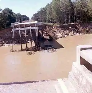
Mississippi Highway 33 bridge failure just north of Rosetta, Mississippi, caused by the April 1974 flood on the Homochitto River.
From north to south
Major intersections
| County | Location | mi | km | Destinations | Notes |
|---|---|---|---|---|---|
| Wilkinson | | Louisiana state line; southern terminus | |||
| Centreville | South end of MS 24 overlap | ||||
| Amite | Downtown Centreville (MS 946) | ||||
| | Western terminus of MS 48 | ||||
| Gloster | North end of MS 24 overlap | ||||
| Wilkinson | | Northern terminus of MS 563 | |||
| Franklin | | ||||
| Jefferson | | South end of MS 28 overlap | |||
| Fayette | Main Street - Fayette | former US 61 | |||
| | North end of MS 28 overlap; northern terminus; western terminus of MS 28 | ||||
1.000 mi = 1.609 km; 1.000 km = 0.621 mi
| |||||
References
- "Mississippi Public Roads Selected Statistics" (PDF). Mississippi Department of Transportation. 2008. Archived from the original (PDF) on 2010-12-03. Retrieved 2010-06-03.
This article is issued from Wikipedia. The text is licensed under Creative Commons - Attribution - Sharealike. Additional terms may apply for the media files.