Montana Highway 200
Montana Highway 200 (MT 200) in the U.S. state of Montana is a route running east–west covering the entire state of Montana. From the starting point at ID 200, near Heron, the highway runs east to ND 200 near Fairview. It is part of a chain of state highways numbered 200 which extend from Idaho across Montana, North Dakota, and Minnesota. At 706.272 mi (1,136.635 km),[1] Montana Highway 200 is also the longest route signed as a state highway in the United States. Highway 200 helps to connect many small towns located in central Montana and the vast plains area of eastern Montana, to larger western Montana cities such as Great Falls and Missoula.
| ||||
|---|---|---|---|---|
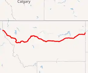
MT 200 highlighted in red | ||||
| Route information | ||||
| Maintained by MDT | ||||
| Length | 706.584 mi[1] (1,137.137 km) | |||
| Existed | October 1967[2]–present | |||
| Major junctions | ||||
| West end | ||||
| East end | ||||
| Location | ||||
| Counties | Richland, Dawson, McCone, Garfield, Petroleum, Fergus, Judith Basin, Cascade, Lewis and Clark, Powell, Missoula, Lake, Sanders | |||
| Highway system | ||||
| ||||

Route description

At its western end at the Idaho state line, MT 200 follows the Clark Fork River at the feet of the Cabinet Mountains eastward for 85 miles (137 km) until it meets the Flathead River at MT 135. It then follows the Flathead River east for 25 miles (40 km) to Dixon where the Flathead River turns north. MT 200 continues east following the Jocko River for 6 miles (10 km) until it intersects with US 93 at Ravalli. The two highways share a 27-mile (43 km) concurrency and travel south I-90, where they head east into Missoula. MT 200 follows I-90 through Missoula for 14 miles (23 km), with US 93 departing and US 12 joining the route along the way, leaving the interstate near Milltown. The highway runs parallel to the Blackfoot River and is subject to hazardous driving conditions in the winter, particularly due to black ice. From I-90, the road travels 74 miles (119 km) east to Lincoln, and another 39 miles (63 km) where it crosses Rogers Pass on the Continental Divide. It continues east for 21 miles (34 km) to Bowman's Corner where it intersects US 287, and then another 30 miles (48 km) to Sun River where it merges with US 89. The two highways travel for 8 miles (13 km) east to I-15 near Vaughn, where they join the interstate and travel south for 12 miles (19 km) to Great Falls.[1][3]
In Great Falls, MT 200 and US 89 leave I-15, where they become concurrent with MT 3, share a brief concurrency with I-315 (I-15 Business), and merge with US 87, following 10th Avenue South eastward through the city. The four routes of US 87, US 89, MT 3, and MT 200 share a 23-mile (37 km) concurrency from Great Falls to Armington Junction (near Belt), where US 89 heads south and the three remaining routes continue east for 65 miles (105 km). At Eddie's Corner (near Moore), the routes meet US 191 where MT 3 and US 191 share a common alignment to Harlowton. US 87, US 191, and MT 200 share a 14-mile (23 km) concurrency to Lewistown, where US 191 heads north, and US 87/MT 200 continue another 34 miles (55 km) to Grass Range. At Grass Range, MT 200 and US 87 end their 135-mile-long (217 km) concurrency and MT 200 continues east for 98 miles (158 km) to MT 59 in Jordan. MT 200 continues 68 miles (109 km) east to Circle where it intersects MT 13 and MT 200S (an auxiliary route that connects MT 200 with Glendive). It continues continues 71 miles (114 km) east until it intersects MT 16 and MT 23, where MT 16 and MT 200 head north into Sydney and share a 2.5-mile-long (4.0 km) concurrency. MT 200 leaves Sydney and travels northeast for 11 miles (18 km) to Fairview, where it turns east and crosses into North Dakota.[1][3]
MT 200 follows the following MDT corridors:
| Corridor | Length (mi) |
Length (km) |
West end | East end | Notes |
|---|---|---|---|---|---|
| P-6 (C000006)[4] | 115.787 | 186.341 | Idaho state line | Ravalli | |
| N-5 (C000005)[5] | 27.215 | 43.798 | Ravalli | Wye | US 93 concurrency |
| I-90 (C000090)[6] | 13.881 | 22.339 | Wye | Bonner | I-90 concurrency |
| N-24 (C000024)[7] | 140.184 | 225.604 | Bonner | Sun River | |
| N-3 (C000003)[8] | 7.763 | 12.493 | Sun River | Vaughn | US 89 concurrency |
| I-15 (C000015)[9] | 11.604 | 18.675 | Vaughn | Great Falls | I-15 concurrency |
| I-315 (C000315)[10] | 0.828 | 1.333 | Great Falls | I-315 concurrency | |
| N-60 (C000060)[11] | 24.726 | 39.793 | Great Falls | Armington | US 87 / US 89 / MT 3 concurrency |
| N-57(C000057)[12] | 279.109 | 449.182 | Armington | Circle | Includes US 87 / US 191 / MT 3 concurrencies |
| P-51 (C000051)[13] | 71.047 | 114.339 | Circle | Jct. MT 16 / MT 23 south of Sidney | |
| N-20 (C000020)[14] | 14.128 | 22.737 | Jct. MT 16 / MT 23 south of Sydney | North Dakota state line | Includes MT 16 concurrency |
History
Today's Highway 200 is part of a four-state chain of such routes, but it did not begin that way. It was assembled from other state and federal routes over the years.
The status of the routes and route segments that became Highway 200 in 1937.[15]
- The section from the Idaho line to Ravalli was the original MT 3.
- No concurrency from Ravalli to Missoula on US 93 or US 10.
- The section from Bonner to Sun River was then MT 20, and much was yet to be constructed. The route even followed segments of today's MT 21 to Augusta and future US 287 (then MT 33).
- No concurrency from Sun River to Grass Range along US 87.
- The section from Grass Range to Circle was part of the original MT 18.
- The remainder of MT 18 ran from Circle to Glendive, today's MT 200S.
- The section from Circle to Sidney was Montana 23, ending at then MT 14.
- MT 14 ran the rest of the way to Fairview.
By 1941, US 10 Alternate (US 10A) had replaced MT 3 as part of an alternate route from Wye to Spokane via Sandpoint and was now concurrent with US 93 to US 10.
Between 1948 and 1959, many construction projects and route redesignations with concurrencies made MT 20 from Bonner to Sidney the baseline for today's MT 200. MT 23N replaced MT 14 from Sidney to Fairview and MT 20S replaced MT 18 from Circle to Glendive.
In 1960, MT 20 picked up the Sidney to Fairview segment.
By 1969, the entire MT 20 had become MT 200 and included the former US 10A from Idaho to Wye, and following US 10/93 through Missoula. MT 20S became 200S.
Major junctions
| County | Location | mi[1] | km | Exit | Destinations | Notes |
|---|---|---|---|---|---|---|
| Sanders | | 0.000 | 0.000 | Continuation into Idaho | ||
| 10.418 | 16.766 | Southern terminus of MT 56 | ||||
| 27.959 | 44.996 | |||||
| 49.102 | 79.022 | Forest Highway 7, seasonal access to Thompson Pass (S-471) and Cooper Pass (FR-7623, Prospect Creek Road) | ||||
| Thompson Falls | 49.544 | 79.733 | ||||
| | 56.013 | 90.144 | ||||
| Plains | 76.706 | 123.446 | Western terminus of MT 28 | |||
| | 85.030 | 136.843 | Northern terminus of MT 135 | |||
| Perma | 95.617 | 153.881 | ||||
| Dixon | 109.750 | 176.626 | ||||
| Lake | Ravalli | 115.787 | 186.341 | Western end of US 93 overlap | ||
| | 126.674 | 203.862 | ||||
| Missoula | Wye | 142.057 | 228.619 | |||
| 143.002 | 230.139 | 96 | Western end of I-90 overlap; exit numbers follow I-90 | |||
| | 146.610 | 235.946 | 99 | Airway Boulevard | ||
| Missoula | 148.386 | 238.804 | 101 | Eastern end of US 93 overlap | ||
| 151.449 | 243.734 | 104 | Orange Street | |||
| 152.313 | 245.124 | 105 | Western end of US 12 overlap | |||
| East Missoula | 153.938 | 247.739 | 107 | East Missoula | ||
| West Riverside | 156.883 | 252.479 | 109 | Eastern end of I-90/US 12 overlap | ||
| Bonner | 157.962 | 254.215 | ||||
| Clearwater Junction | 189.463 | 304.911 | ||||
| Powell | | 210.306 | 338.455 | |||
| Lewis and Clark | | 240.582 | 387.179 | |||
| Rogers Pass | 245.283 | 394.745 | Continental Divide (elevation 5,610 ft or 1,710 m) | |||
| | 258.021 | 415.245 | ||||
| Bowman's Corner | 266.653 | 429.136 | ||||
| Cascade | Simms | 284.907 | 458.513 | |||
| 285.105 | 458.832 | |||||
| Sun River | 297.067 | 478.083 | Western end of US 89 overlap | |||
| Vaughn | 305.042 | 490.918 | 290 | Western end of I-15 overlap; exit numbers follow I-15 | ||
| | 309.140 | 497.513 | 286 | Manchester | ||
| 313.018 | 503.754 | 282 | Eastbound exit and westbound entrance | |||
| Great Falls | 314.997 | 506.939 | 280 | |||
| 316.586 | 509.496 | 278 — | Eastern end of I-15 overlap; western end of I-315 / I-15 Bus. / MT 3 overlap western termini of unsigned I-315 / I-15 BL / MT 3 | |||
| 316.921 | 510.035 | 0 | 14th Street SW | Exit number follows I-15 Bus. (I-315) | ||
| 317.414 | 510.828 | Fox Farm Road / 6th Street SW | Eastern terminus of I-315 and overlap | |||
| 318.842– 318.927 | 513.126– 513.263 | One way pair; eastern end of I-15 Bus. overlap | ||||
| 319.580– 319.660 | 514.314– 514.443 | One way pair; western end of US 87 overlap | ||||
| 322.760 | 519.432 | |||||
| | 315.779 | 508.197 | ||||
| 338.597 | 544.919 | |||||
| Armington Junction | 342.200 | 550.718 | Eastern end of US 89 overlap | |||
| Judith Basin | | 352.727 | 567.659 | |||
| Geyser | 363.607 | 585.169 | ||||
| | 378.899 | 609.779 | ||||
| 385.004 | 619.604 | |||||
| 391.951 | 630.784 | |||||
| Moccasin | 396.968 | 638.858 | ||||
| | 400.744 | 644.935 | ||||
| Fergus | Eddies Corner | 406.897 | 654.837 | Eastern end of MT 3 overlap; western end of US 191 overlap | ||
| | 421.232 | 677.907 | Eastern end of US 191 overlap | |||
| Lewistown | 421.232 | 677.907 | ||||
| | 454.758 | 731.862 | Eastern end of US 87 overlap; southern terminus of MT 19 | |||
| Petroleum | Winnett | 477.375 | 768.261 | |||
| | 499.215 | 803.409 | ||||
| Garfield | | 552.485 | 889.138 | |||
| Jordan | 553.355 | 890.539 | Access to Hell Creek State Park via S-543 (jct 280 ft from MT 200) | |||
| | 558.383 | 898.630 | ||||
| 579.279 | 932.259 | |||||
| Garfield–McCone county line | Flowing Well | 588.930 | 947.791 | |||
| McCone | | 607.933 | 978.373 | |||
| 618.423 | 995.255 | |||||
| Circle | 619.496 | 996.982 | ||||
| 620.265 | 998.220 | |||||
| | 621.309 | 999.900 | ||||
| Dawson | Richey | 649.106 | 1,044.635 | |||
| Richland | | 692.356 | 1,114.239 | Western end of MT 16 overlap | ||
| Sidney | 694.924 | 1,118.372 | Eastern end of MT 16 overlap | |||
| Fairview | 706.223 | 1,136.556 | ||||
| | 706.584 | 1,137.137 | Continuation into North Dakota | |||
1.000 mi = 1.609 km; 1.000 km = 0.621 mi
| ||||||
Related route
| |
|---|---|
| Location | Circle–Glendive |
| Length | 45.280 mi[1] (72.871 km) |
| Existed | 1967[16]–present |
Montana Highway 200S (MT 200S) is a spur route of MT 200 that branches off the main route near Circle and ends at the I-94 business loop in Glendive. MT 200S was originally part of MT 18, renamed MT 20S when MT 23 from Circle to Sidney was renamed MT 20 and received its current name when MT 20 was renamed MT 200.[16] In the state road log, MT 200S picks up the mileposts from route N-57 (C000057) from mileposts 279.109 to 323.472, for a total of 45.280 miles (72.871 km).
Major intersections
| County | Location | mi | km | Destinations | Notes |
|---|---|---|---|---|---|
| McCone | | 0.000 | 0.000 | Western terminus | |
| Dawson | Lindsay | 23.178 | 37.301 | ||
| 23.965 | 38.568 | ||||
| West Glendive | 44.363 | 71.395 | I-94 exit 211; westbound exit and eastbound entrance | ||
| 45.280 | 72.871 | ||||
| 1.000 mi = 1.609 km; 1.000 km = 0.621 mi | |||||
See also
 U.S. Roads portal
References
- Data and Statistics Bureau (2019). Montana Road Log (PDF) (Report). Helena: Montana Department of Transportation. Retrieved December 24, 2020.
- "New Map Changes Route 20". The Havre Daily News. October 18, 1967. p. 4. Retrieved June 19, 2018 – via Newspapers.com.

- Montana Department of Transportation (2019). Montana Official Highway Map (PDF) (Map). Helena: Montana Department of Transportation. §§ B-1, C-1, C-2, D-2, E-2, E-3, E-4, D-4, C-5, D-5, D-6, D-7, D-8, D-9, D-10, D-11, C-11, C-12. Retrieved January 2, 2021.
- MDT 2019, pp. 171–175: MP 0.000–115.787
- MDT 2019, pp. 57–58: MP 27.215–0.000
- MDT 2019, pp. 12–13: MP 95.483–109.364
- MDT 2019, pp. 95–98: MP 0.000–140.184
- MDT 2019, pp. 52–53: MP 7.975–0.000
- MDT 2019, p. 8: MP 289.607–278.063
- MDT 2019, p. 25: MP 0.000–0.828
- MDT 2019, pp. 119–121: MP 96.145–71.359
- MDT 2019, pp. 113–118: MP 0.000–279.109
- MDT 2019, p. 218: MP 0.000–71.047
- MDT 2019, pp. 89–90: MP 49.605–63.833
- Texaco; Rand McNally and Company (1937). Road map: Idaho, Mont., Wyo (Map). Chicago: Rand McNally and Company. Retrieved April 28, 2017 – via David Rumsey Map Library.
- "Highway Route Number Changed". The Billings Gazette. October 2, 1967. p. 27. Retrieved June 19, 2018 – via Newspapers.com.
External links
| Wikimedia Commons has media related to Montana Highway 200. |