Mount Alexander Road, Melbourne
Mount Alexander Road is a major road in Melbourne's inner northern suburbs.[1]
Mount Alexander Road | |
|---|---|
 | |
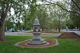
Memorial to Dr. Sutherland with Mount Alexander Road in the background | |

| |
| General information | |
| Type | Road |
| Length | 7 km (4.3 mi) |
| Former route number | |
| Major junctions | |
| Northwest end | |
| |
| Southeast end | |
| Location(s) | |
| Major suburbs | Essendon, Moonee Ponds, Ascot Vale |
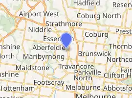
It commences at the junction of Flemington Road and CityLink in the suburb of North Melbourne, proceeds North through Flemington forming the boundary between Flemington and Travancore, then forming the boundary between Travancore and Ascot Vale, then through Moonee Ponds and the Moonee Ponds Junction, continuing on North of the junction as a much wider roadway with a plantation separating northbound and southbound traffic. The road then continues on through Moonee Ponds, then Essendon, before terminating at the intersection of Bulla Road, Keilor Road and Lincoln Road.
Mount Alexander Road was named as its original destination was the Gold Fields of Mount Alexander, now known as Castlemaine.
Melbourne tram route 59 runs along the majority of the road, sharing traffic lanes with motor vehicles between Flemington Road and Moonee Ponds Junction, and along reserved tracks between Fletcher Street and Keilor Road in Essendon. Essendon tram depot is also located on the road, in the suburb of Travancore.
See also
![]() Australian Roads portal
Australian Roads portal
References
- VicRoads. "VicRoads – Register of Public Roads (Part A)". Government of Victoria. p. 778. Archived from the original (PDF) on 29 December 2014. Retrieved 25 February 2015.