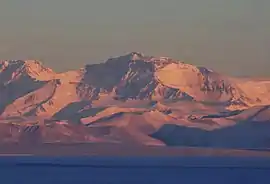
Mount Lister
Mount Lister is a massive mountain, 4,025 metres (13,200 ft) high, forming the highest point in the Royal Society Range of Victoria Land, Antarctica. It was discovered by the British National Antarctic Expedition (1901–04) which named it for Lord Joseph Lister, President of the Royal Society, 1895–1900.[1]
| Mount Lister | |
|---|---|
 Mount Lister, seen from Ross Island | |
| Highest point | |
| Elevation | 4,025 metres (13,200 ft) [1] |
| Prominence | 2,325 m (7,628 ft) [2] |
| Listing | Ultra |
| Coordinates | 78°04′S 162°41′E [1] |
| Geography | |
 Mount Lister | |
| Parent range | Royal Society Range |
Waikato Spur, a rock spur about 3 nmi (5.6 km) long, extends northwestward from Mount Lister. The spur separates the upper part of Emmanuel Glacier from the Carleton Glacier. The spur was named by the US Advisory Committee on Antarctic Names (US-ACAN) in 1994 after the University of Waikato in Hamilton, New Zealand, in association with nearby features that are named after colleges and universities.[3]
See also
References
- "Mount Lister". Geographic Names Information System. United States Geological Survey. Retrieved 2020-05-10.
- "Antarctica Ultra-Prominences" Peaklist.org. Retrieved 2011-12-08.
- "Waikato Spur". Geographic Names Information System. United States Geological Survey. Retrieved 2020-05-10.
![]() This article incorporates public domain material from the United States Geological Survey document: "Mount Lister". (content from the Geographic Names Information System)
This article incorporates public domain material from the United States Geological Survey document: "Mount Lister". (content from the Geographic Names Information System)