Nevada State Route 856
State Route 856 (SR 856) is a state highway in Pershing County, Nevada serving Lovelock. The western portion of the route is also signed as Interstate 80 Business.
| ||||
|---|---|---|---|---|
| Airport Road | ||||

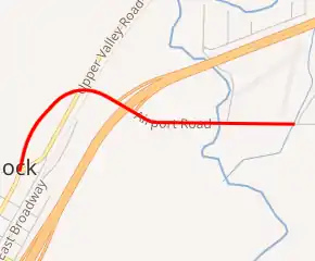
SR 856 highlighted in red | ||||
| Route information | ||||
| Maintained by NDOT | ||||
| Length | 1.398 mi[1] (2.250 km) | |||
| Existed | 1976–present | |||
| Major junctions | ||||
| West end | ||||
| East end | Reservoir Road near Lovelock | |||
| Location | ||||
| Counties | Pershing | |||
| Highway system | ||||
| ||||
Route description
State Route 856 begins as a continuation of Cornell Avenue (I-80 Bus.) at the intersection of Upper Valley Road (State Route 396) and 14th Street in northwestern Lovelock. The highway heads northeast as Airport Road, crossing over Upper Valley Road, an irrigation canal, and the Union Pacific Railroad tracks towards a half-interchange with Interstate 80 and U.S. Route 95. The route then continues east, crossing the Humboldt River and passing south of the now-abandoned Lovelock Airpark, reaching its terminus near the intersection of Reservoir Road.[2]

Cornell Avenue, as a historic routing of U.S. Route 40–95,[3] is designated as Interstate 80 Business through Lovelock. SR 856 carries the business loop from the northern end of Lovelock back to I-80, since Cornell Avenue does not intersect the interstate.[2]
History
Airport Road appears on maps as early as 1954, although it was not assigned a state highway number at the time.[4] The road was assigned to State Route 856 on July 1, 1976.[5]
Major intersections
The entire route is in Pershing County.
| Location | mi[6] | km | Destinations | Notes | |
|---|---|---|---|---|---|
| Lovelock | 0.00 | 0.00 | West end of I-80 Business overlap | ||
| | East end of I-80 Business; I-80 exit 107; No access from I-80 eastbound or to I-80 westbound | ||||
| | 1.39 | 2.24 | Reservoir Road / Airport Road | ||
1.000 mi = 1.609 km; 1.000 km = 0.621 mi
| |||||
See also
 United States portal
 U.S. Roads portal
References
- Nevada Department of Transportation (January 2017). "State Maintained Highways of Nevada: Descriptions and Maps". Retrieved 2017-01-12.
- Lovelock Area (PDF) (Map). Nevada Department of Transportation. 2004. Archived from the original (PDF) on 2009-08-10. Retrieved 2009-07-08.
- "Lovelock Area". Nevada Department of Highways. 1968. Retrieved 2009-07-08.
See TIFF image in file 'pershingcounty1968lovelock.zip'
- "General Highway Map – Pershing County, Nevada (sheet 1 of 2)". Nevada State Highway Department. 1954. Retrieved 2009-07-08.
See TIFF image in file 'PershingCounty1954_001.zip'
- Nevada State Maintained Highways: Descriptions, Index and Maps. Nevada Department of Transportation. January 2001. p. 113.
- Nevada Department of Transportation (May 2008). "Maps of Milepost Location on Nevada's Federal and State Highway System by County" (PDF). Archived from the original (PDF) on 2009-02-19. Retrieved 2009-07-08.
| Wikimedia Commons has media related to Nevada State Route 856. |
