New Mexico State Road 347
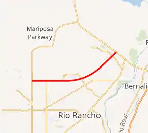
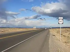
State Road 347 (NM 347) is a partially completed road that starts at Interstate 40 on the West Mesa, approximately 8 miles (12.9 km) west of downtown Albuquerque. It runs north-northeast, following Paseo del Volcan to its northern terminus at US-550 in Bernalillo. Currently it exists in two discontinuous segments: the southern segment is 9.4 miles (15.1 km) long, and follows Paseo del Volcan from I-40 to Paseo del Norte (NM 423) near Double Eagle II Airport. The 10.2 miles (16.4 km) northern section begins at Unser Boulevard in Rio Rancho and ends at US-550 in Bernalillo, which incorporates a 3.4 mile extension of Paseo del Volcan from Iris Road to US-550 that was completed in February 2011. The remaining 10 miles (16.1 km) segment from Paseo del Norte to Unser Boulevard is not yet built. While the New Mexico Department of Transportation owns the right-of-way for the unbuilt section, its completion is contingent upon future growth within Albuquerque and Rio Rancho and the availability of funding.
| ||||
|---|---|---|---|---|
| Paseo del Volcan | ||||

NM 347 highlighted in red | ||||
| Route information | ||||
| Maintained by NMDOT | ||||
| Length | 29.477 mi[1] (47.439 km) | |||
| Existed | 2010[2]–present | |||
| Major junctions | ||||
| South end | ||||
| North end | ||||
| Location | ||||
| Counties | Bernalillo, Sandoval | |||
| Highway system | ||||
| ||||

Currently a 2-lane road, NM 347 right-of-way is 150 feet wide to accommodate expansion to a freeway, should future growth and traffic demand necessitate the construction of a freeway along the Paseo del Volcan corridor.[3]
History
An environmental impact statement for the Paseo del Volcan project was approved in August 2001 by the Federal Highway Administration (FHWA).[4]:7–8 Phase 1 of the project, a 3.9-mile (6.3 km) segment between Unser Blvd. and Iris Road was completed in October 2006.[5] The road was designated as State Road 347 between I-40 and US 550 in August 2010.[2] The Phase 2 extension 3.4 miles (5.5 km) eastward to US 550 was opened to traffic in February 2011.[3] Land acquisition is currently in progress for a further extension westward from Unser Blvd. to Rainbow Blvd.[4]:4,8 In July 2011, a street west of Albuquerque also known as Paseo del Volcan was renamed Atrisco Vista Blvd. to avoid a naming conflict.[6] Atrisco Vista Blvd. intersects I-40 at Exit 149 only 1.5 miles (2.4 km) east of the proposed interchange with NM 347.[4]:5 Interchange construction at I-40 will be Phase 3 of the project and awaits acquisition of individual private parcels along the Interstate.[4]:5
Long-range planning anticipates the roadway requiring four to five additional lanes by 2035.[7]:12 Extending the road to I-25 and even eventually linking the road to I-25 both to the north and south creating a western bypass in metropolitan Albuquerque are also under consideration.[7]:15
Major intersections
The following only represents the roadway as completed and open to traffic. The entire route is in Rio Rancho, Sandoval County.
| mi[2] | km | Destinations | Notes | ||
|---|---|---|---|---|---|
| 0.00 | 0.00 | Unser Boulevard – Albuquerque | Current southern terminus | ||
| 7.14 | 11.49 | Northern terminus | |||
| 1.000 mi = 1.609 km; 1.000 km = 0.621 mi | |||||
See also
 U.S. Roads portal
References
- "TIMS Road Segments by Posted Route/Point with AADT Info; NM, NMX-Routes" (PDF). New Mexico Department of Transportation. April 3, 2013. p. 49. Retrieved December 28, 2013.
- "Minutes of the regular meeting of the New Mexico State Transportation Commission" (PDF). August 19, 2010. pp. 8–9. Archived from the original (PDF) on July 22, 2013. Retrieved December 28, 2010.
- Littman, Ali (February 7, 2011). "Paseo del Volcan extension opens Monday". Rio Rancho Observer. Retrieved December 28, 2013.
- Abbo, Tony S. (November 20, 2013). "Paseo Del Volcan (NM 347)" (PDF). New Mexico Department of Transportation. Retrieved December 28, 2013.
- Herron, Gary (February 14, 2011). "Paseo del Volcan extension now open". Rio Rancho Observer. Retrieved December 28, 2013.
- Staff (July 9, 2011). "Atrisco Vista Blvd. New Name on I-40". Albuquerque Journal. Retrieved December 28, 2013.
- "Paseo del Volcan" (PDF). City of Albuquerque. February 6, 2013. Retrieved December 28, 2013.
External links
![]() Geographic data related to New Mexico State Road 347 at OpenStreetMap
Geographic data related to New Mexico State Road 347 at OpenStreetMap
