North Cape (Norway)
North Cape (Norwegian: Nordkapp; Northern Sami: Davvenjárga) is a cape on the northern coast of the island of Magerøya in Northern Norway. The cape is in Nordkapp Municipality in Troms og Finnmark county, Norway. The European route E69 highway has its northern terminus at North Cape, which makes it the northernmost point in Europe that can be accessed by car and makes the E69 the northernmost public road in Europe. The plateau is a popular tourist attraction. The cape includes a 307-metre-high cliff (1,007 ft) with a large flat plateau on top, where visitors, weather permitting, can watch the midnight sun and views of the Barents Sea to the north. North Cape Hall, a visitor centre, was built in 1988 on the plateau. It includes a café, restaurant, post office, souvenir shop, a small museum, and video cinema.[1][2]
| North Cape | |
|---|---|
| Nordkapp | |
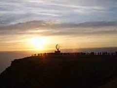
 Midnight sun at the North Cape | |
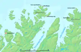
 Location of the cape | |
| Location | Troms og Finnmark, Norway |
| Coordinates | 71°10′21″N 25°47′04″E |
| Offshore water bodies | Barents Sea |
| Elevation | 307 metres (1,007 ft) |
Geography

The steep cliff of the North Cape is located at 71°10′21″N 25°47′04″E, about 2,102.3 km (1,306.3 mi) from the North Pole. Nordkapp is often inaccurately referred to as the northernmost point of Europe. However, the neighbouring Knivskjellodden Cape actually extends 1,450 m (4,760 ft) further north. Furthermore, both of these points are situated on an island (Magerøya), albeit one connected by road to the mainland. The northernmost point of mainland Europe is located at Cape Nordkinn (Kinnarodden) which lies about 5.7 km (3.5 mi) further south and about 70 km (43 mi) to the east. That point is located near the village of Mehamn on the Nordkinn Peninsula. The northernmost point of Europe including islands is hundreds of kilometers further north, either in Russia's Franz Josef Land or Norway's Svalbard archipelago, depending on whether Franz Josef Land is considered to be in Europe or in Asia.
The North Cape is the point where the Norwegian Sea, part of the Atlantic Ocean meets the Barents Sea, part of the Arctic Ocean. The midnight sun can be seen from 14 May to 31 July. The sun reaches its lowest point between 12:14 am and 12:24 am (00:14 and 00:24) during those days.
.jpg.webp)
Transport
The North Cape is reached by European route E69 highway through the North Cape Tunnel, an undersea tunnel connecting the island of Magerøya to the mainland. The EuroVelo bicycle routes EV1, EV7 and EV11 connect the North Cape to Sagres, Portugal,[3] Malta and Athens, respectively.
Several cruise ships visit North Cape every year. Honningsvåg is one of the main stops of the Hurtigruten coastal ships.
Regular buses run from the nearby town of Honningsvåg to the North Cape (33 km (21 mi)), and coaches meet the many cruise ships that call at the port of Honningsvåg.
The nearest airport is Honningsvåg Valan Airport (HVG), which offer several flights to and from Tromsø Langnes International Airport (TOS).[4]
Road distance to North Cape from different towns:
- Honningsvåg; 33 kilometres (20.5 mi)
- Lakselv; 194 kilometres (120.5 mi)
- Hammerfest; 205 kilometres (127.4 mi)
- Alta; 237 kilometres (147.3 mi)
- Kirkenes; 530 kilometres (329.3 mi)
- Tromsø; 592 kilometres (367.9 mi)
Winter
It is possible to visit North Cape during winter, but when there is heavy snow and wind, the last stretch of road is only open for convoy driving at certain times. The road to North Cape is kept open during winter and is accessible to regular vehicles and drivers that both can cope with the hard snow and wind conditions that may occur in winter. Before this, E69 was the only winter-closed E-route in Europe.
History

The North Cape was named by the Englishman Steven Borough, captain of the Edward Bonaventure, which sailed past in 1553 in search of the Northeast Passage.[1]
Early tourism
The North Cape became a popular tourist destination during the last decades of the nineteenth century, especially after King Oscar II's visit in 1873.[5] Regular coastal steamer routes from Germany to Northern Norway established in this period facilitated these visits, and Thomas Cook & Son began arranging tours to the destination as early as 1875.[5] Tourists who climbed the cape would often do so using a path equipped with wired ropes from Hornviken.[5] They would often celebrate the visit with the writing of postcards, so-called "Cape cards", gazing at the midnight sun.[5]
Monuments and buildings
A granite column was erected commemorating the visit of King Oscar II of Norway and Sweden in 1873 and the visit of German Emperor Wilhelm II (in 1891) was also marked with a memorial.[5] In 1891–92, an octagonal wooden building was erected on top of the cape, later named "Stoppenbrinck's" (or "Stoppenbrink's") "Champagne Pavilion".[5]
World War II
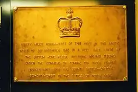
In 1943, the Battle of North Cape was fought in the Arctic Ocean off this cape, where the German battleship Scharnhorst was eventually sunk by gunfire from the British battleship HMS Duke of York and torpedoes from the Norwegian destroyer HNoMS Stord, and other ships of the British Navy.
Road access
A road to the North Cape was first built in 1956.[5]
Admission fee controversy
As of 2011, an adult ticket to the North Cape visitor centre cost between 160 and 235 kr.[6] Often there is fog (since the plateau is above the common cloud base), which obscures the view. There is no discount for this situation, but the full price ticket is valid for multiple entries within 48 hours.
In 2000, and again in 2011, the Norwegian Ministry of the Environment responded to pressure from interest groups and asked Nordkapps VEL, the company that maintains the site, to reduce the admission fee to the plateau.[6] Nordkapps VEL responded that the 8,000 daily visitors and distant location places great demands on the operations, maintenance, and security of the facilities and natural features of the large site.[6] The fee was not lowered, and has since been slightly increased although visitors arriving by foot, bicycle, or other non-motorized vehicles are nowadays offered free entrance.[7]
Sport and leisure
The 2009 Trans Europe Foot Race started in Bari, Italy and finished at North Cape. The total distance was 4,485 kilometres (2,787 mi).
The NorthCape4000 is a bicycle race that finishes at the North Cape. The total distance is around 4,200 kilometres (2,600 mi).[8]
The first stage of the 2014 Arctic Race of Norway was held on North Cape on 14 August 2014. The bicycle race started in Hammerfest, finishing on North Cape and was won by Norwegian, Lars Petter Nordhaug for Team Jumbo–Visma in a time of 4 hours 51 minutes 3 seconds.[9]
The record of cycling from the northern to the southern end of Norway, North Cape to Lindesnes, is 4 days, 22 hours and 18 minutes, performed by a group of five men from Rye in Oslo, in July 2003.[10]
In popular culture
Footage from the North Cape is featured frequently in films and television, most notably in the 2014 action comedy film Børning, which revolves around an illegal street race from south of Oslo to the North Cape.
Gallery
 North Cape Hall
 Entrance of North Cape Hall
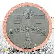
 Children of the World sculpture
 Battle of North Cape commemorative plaque
 Midnight at North Cape
.jpg.webp) North Cap Milestone
North Cap Milestone Globe at North Cape
 Nordkapp by Peder Balke (1804-1887)
 Norwegian National Trekking Association cairn (at Knivskjellodden)
 King Oscar II Obelisk
References
- Svein Askheim. "Nordkapp". Store norske leksikon. Retrieved 1 November 2017.
- "The northernmost point of Europe". Innovation Norway. Retrieved 1 November 2017.
- Svein Askheim. "Magerøya". Store norske leksikon. Retrieved 1 November 2017.
- https://www.wideroe.no/en Widerøe Airlines, official website
- Spring, Ulrike (2017). "Early Mass Tourism at the North Cape: Infrastructure, Environment and Social Practices". In Hansson, Heidi; Ryall, Anka (eds.). Arctic Modernities: The Environmental, the Exotic and the Everyday. Newcastle: Cambridge Scholars. pp. 130–157. ISBN 978-1-5275-0290-1.
- "Krangel om 235 kroner". E24 Næringsliv (in Norwegian). 1 September 2011. Retrieved 27 January 2018.
- "Opening hours and Prices".
- "NorthCape4000". Official website. Retrieved 26 July 2018.
- "Hammerfest/Nordkapp". Arctic Race of Norway. Amaury Sport Organisation. Archived from the original on 8 January 2015. Retrieved 24 August 2014.
- Ny sykkelrekord
External links
| Wikimedia Commons has media related to North Cape. |
| Wikisource has the text of the 1905 New International Encyclopedia article "North Cape". |
| Wikivoyage has a travel guide for Nordkapp. |