Ohio State Route 519
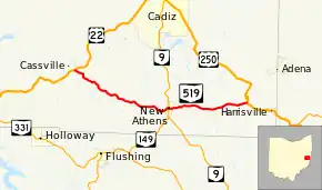
State Route 519 (SR 519) is an east–west state highway situated in eastern Ohio, a U.S. state. The highway runs from its western terminus at U.S. Route 22 approximately 6 miles (9.7 km) northwest of New Athens to its eastern terminus at U.S. Route 250 about 1 mile (1.6 km) northwest of Harrisville.
| ||||
|---|---|---|---|---|
 | ||||
| Route information | ||||
| Maintained by ODOT | ||||
| Length | 11.08 mi[1] (17.83 km) | |||
| Existed | 1937–present | |||
| Major junctions | ||||
| West end | ||||
| East end | ||||
| Location | ||||
| Counties | Harrison | |||
| Highway system | ||||
| ||||
Found exclusively in the southeastern portion of Harrison County, State Route 519 was first designated in the late 1930s. While predominantly a winding rural two-lane highway, State Route 519 serves the community of New Athens, where it intersects State Route 9.
Route description
The entirety of State Route 519 is situated within the southeastern quadrant of Harrison County. There is no portion of this state route that is inclusive within the National Highway System.[2]
History
State Route 519 made its first appearance in 1937 along the routing between U.S. Route 22 and U.S. Route 250 that it occupies to this day. No significant changes have taken place to the routing of State Route 519 since its designation.[3][4]
Major intersections
The entire route is in Harrison County.
| Location | mi[1] | km | Destinations | Notes | |
|---|---|---|---|---|---|
| Moorefield Township | 0.00 | 0.00 | |||
| New Athens | 6.42 | 10.33 | |||
| Short Creek Township | 11.08 | 17.83 | |||
| 1.000 mi = 1.609 km; 1.000 km = 0.621 mi | |||||
References
- Ohio Department of Transportation. "Technical Services Straight Line Diagrams" (PDF). Retrieved January 9, 2014.
- National Highway System: Ohio (PDF) (Map). Federal Highway Administration. December 2003. Retrieved 2010-08-19.
- Ohio State Map (Map). Ohio Department of Transportation. 1936.
- Ohio State Map (Map). Ohio Department of Transportation. 1937.
