Ohio State Route 723
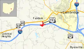
State Route 723 (SR 723) is a very short state highway located in east-central Ohio. Having a length of just 0.85 miles (1.37 km) and located just southwest of Cambridge, the route serves as a connector between Interstate 70 (I-70) at its exit 176 and the concurrency of U.S. Route 22 (US 22) and US 40.
| ||||
|---|---|---|---|---|
 | ||||
| Route information | ||||
| Maintained by ODOT | ||||
| Length | 0.85 mi[1] (1.37 km) | |||
| Major junctions | ||||
| South end | ||||
| North end | ||||
| Location | ||||
| Counties | Guernsey | |||
| Highway system | ||||
| ||||
Route description
The short SR 723 commences at I-70's exit 176, a trumpet interchange in Guernsey County's Cambridge Township. Heading north from I-70 as a four-lane highway, SR 723 passes over the CSX railway and crosses the city limits of Cambridge. A short distance later, SR 723 comes to an end as it meets US 22 and US 40 at a signalized T-intersection.[2]
SR 723 is not considered a part of the National Highway System.[3]
History
The roadway that carries SR 723 was constructed by 1961.[4] For the first few years of its existence, SR 723 served as the western end of a section of I-70 that was complete.[5][6][7][8] By 1967, I-70 was navigable in both directions from SR 723.[9] Since then, no major changes have occurred to the route.
Major intersections
The entire route is in Guernsey County.
| Location | mi[1] | km | Destinations | Notes | |
|---|---|---|---|---|---|
| Cambridge Township | 0.00– 0.56 | 0.00– 0.90 | Exit 176 (I-70) | ||
| Cambridge | 0.85 | 1.37 | |||
| 1.000 mi = 1.609 km; 1.000 km = 0.621 mi | |||||
References
- "DESTAPE - Guernsey County" (PDF). Ohio Department of Transportation. June 24, 2015. Retrieved November 1, 2015.
- Google (November 1, 2015). "Overview Map of State Route 723" (Map). Google Maps. Google. Retrieved November 1, 2015.
- National Highway System: Ohio (PDF) (Map). Federal Highway Administration. December 2003. Retrieved 2010-05-03.
- Ohio Department of Transportation. "Technical Services Straight Line Diagrams" (PDF). Retrieved 2013-07-08.
- 1962 Official Ohio Highway Map (MrSID) (Map). Cartography by P.E. Masheter, Director. Ohio Department of Highways. 1962. Retrieved September 2, 2013.
- Ohio Official Highway Map (MrSID) (Map). Cartography by ODOH. ODOH. 1964. Retrieved September 2, 2013.
- See the Wonderful World of Ohio (MrSID) (Map). Cartography by ODOH. ODOH. 1965. Retrieved September 2, 2013.
- See the Wonderful World of Ohio (MrSID) (Map). Cartography by ODOH. ODOH. 1966. Retrieved September 22, 2013.
- 1967 Official Highway Map (MrSID) (Map). Cartography by P.E. Masheter, Director. ODOH. 1967. Retrieved September 22, 2013.
