Orangi Town
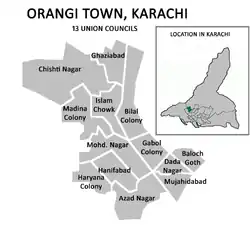
Orangi Town (Sindhi: اُورنگي ٽاؤن, Urdu: اُورنگی ٹاؤن) lies in the northwestern part of the city that was named after the sprawling municipality of Orangi. Orangi Town was formed in 2001 as part of The Local Government Ordinance 2001, and was subdivided into 13 union councils. The town system was disbanded in 2011,[1] and Orangi Town was re-organized as part of Karachi West District in 2015.
Orangi Town
اُورنگی ٹاؤن | |
|---|---|
 Orangi Town was split into 13 Union Councils | |
| Country | Pakistan |
| Province | Sindh |
| City District | Karachi |
| Established | 2001 |
| Disbanded | 2011 |
| Union Councils | |
| Area | |
| • Total | 60 km2 (22 sq mi) |
| Population (2010) | |
| • Total | 1,540,420 |
Location
Orangi Town was bordered by New Karachi Town to the north across the Shahrah-e-Zahid Hussain, Gulberg Town to the east across the Gujjar Nala stream, Liaquatabad Town to the south, and SITE Town to the west. There were 13 official neighborhoods, called union councils.
History
The federal government introduced local government reforms in the year 2000, which eliminated the previous "third tier of government" (administrative divisions) and replaced it with the fourth tier (districts). The effect in Karachi was the dissolution of the former Karachi Division in 2001, and the merging of its five districts to form a new Karachi City-District with eighteen autonomous constituent towns including Kemari Town. In 2011, the system was disbanded but remained in place for bureaucratic administration until 2015, when the Karachi Metropolitan Corporation system was reintroduced. In 2015, Kemari Town was re-organized as part of Karachi West district
Localities within Orangi Town
GULSHAN-E-BAHAR
Baloch Goth
Bilal Colony
Chisti Nagar
Raees Amrohi Colony
Data Nagar
Ghabool Town
Ghaziabad
Hanifabad
Haryana Colony
Iqbal Baloch Colony
Madina Colony
Mohammad Nagar
Mominabad
Mujahidabad
See also
References
- Abbasi, Saeed (10 July 2011). "Karachi's district status restored, notification issued". The News Tribe. Retrieved 16 April 2020.