Río Grande de Arecibo
The Río Grande de Arecibo (Arecibo River) is a river of Puerto Rico. The headwaters lie in the mountains to the south of Adjuntas. From there it flows north until it reaches the Atlantic Ocean near Arecibo.[1] The tributaries lie along the side of the Cerro de Punta and the Utuado pluton. It flows through the northern, passing along a gorge that is 200 m deep and 800–1,200 m wide. It flows through the middle of Puerto Rico[2]
| Río Grande de Arecibo | |
|---|---|
 Río Grande de Arecibo | |
| Location | |
| Commonwealth | Puerto Rico |
| Municipality | Arecibo |
| Physical characteristics | |
| Source | |
| • location | Río Vacadas |
| Mouth | |
• location | Arecibo Bay, Atlantic Ocean |
| Length | 52.89 km (32.86 mi) |
The tributaries to Río Grande de Arecibo are Vacas, Pellejas, Garzas, Saltillo, Cidra, Grande de Jayuya, Caguana, Caonillas, Yunés, Limón, Jauca, Tanamá and Santiago rivers.[3]
Flood control project
In mid 2018, the United States Army Corps of Engineers announced it would be undertaking a major flood control project of the river, with a budget of $82.9 million.[4]
Gallery
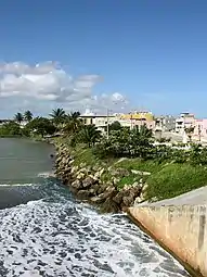 View of Arecibo from the mouth of Río Grande de Arecibo
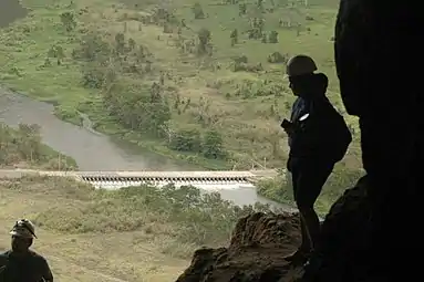 View of the river from Cueva Ventana
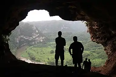 Río Grande de Arecibo from Cueva Ventana after it rained
See also
References
- Fewkes, J. Walter (1903). "Prehistoric Porto Rican Photographs". American Anthropologist. 5 (1): 44. doi:10.1525/aa.1903.5.3.02a00020.
- Monroe, Watson H. (1980). Some Tropical Landforms of Puerto Rico. Geological Survey professional paper 1159. Department of the Interior. p. 12.
- Rio Grande de Arecibo, Puerto Rico: Environmental Impact Statement. 1991. pp. 6–.
- "USACE: $3.348 billion go toward reducing flood risk in Florida, Puerto Rico and USVI". Caribbean Business. 6 July 2018.