Rose Island, Bahamas
Rose Island is a small island in the Bahamas that lies 5 kilometres (3 mi) east of Paradise Island, which lies directly off of New Providence Island. The island has no formal residential infrastructure and no roads. The center 2.5 km2 (1 sq mi) was owned by Claude Turner for around 36 years up until 2005. The largest mass of the island is made up of a shallow inland lagoon in the center of the island. The highest elevation on the island is 16 m (52 ft). The island has a thin peninsula which juts out 11 km (7 mi) east.
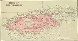
 ROSE ISLḌ on the Edward Stanford 1901 atlas map page inset of New Providence Island | |
 Rose Island The location of Rose Island within the Bahamas | |
| Geography | |
|---|---|
| Location | Atlantic Ocean |
| Coordinates | 25°05′15″N 77°13′10″W |
| Archipelago | Lucayan Archipelago |
| Administration | |
| Additional information | |
| Time zone |
|
| • Summer (DST) |
|
| ISO code | BS-NP |
The island was home to a pineapple plantation centuries ago.
The island's coast was the filming location for the crash-landing of a Vulcan Bomber in the 1965 James Bond film Thunderball.[1]
References
- "Rose Island, New Providence Island, Bahamas". www.imbd.com. IMDb.com, Inc. Retrieved 5 February 2014.
This article is issued from Wikipedia. The text is licensed under Creative Commons - Attribution - Sharealike. Additional terms may apply for the media files.