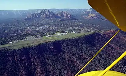
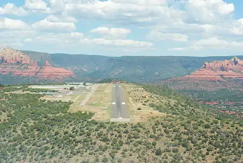
Sedona Airport
Sedona Airport (IATA: SDX, ICAO: KSEZ, FAA LID: SEZ) is a small non-towered airport located 2 miles (1.7 nmi; 3.2 km) southwest of the central business district of Sedona, a city in Yavapai County, Arizona, United States. The airport covers 220 acres (89 ha) and has one runway and one helipad.[1]
Sedona Airport | |||||||||||
|---|---|---|---|---|---|---|---|---|---|---|---|
 | |||||||||||
| Summary | |||||||||||
| Airport type | Public | ||||||||||
| Owner | Yavapai County | ||||||||||
| Location | Sedona, Arizona | ||||||||||
| Elevation AMSL | 4,830 ft / 1,472 m | ||||||||||
| Coordinates | 34°51′00″N 111°47′24″W | ||||||||||
| Website | http://sedonaairport.org/ | ||||||||||
| Map | |||||||||||
 SEZ  SEZ | |||||||||||
| Runways | |||||||||||
| |||||||||||
| Helipads | |||||||||||
| |||||||||||
| Statistics (2006) | |||||||||||
| |||||||||||
Although most U.S. airports use the same three-letter location identifier for the FAA and IATA, Sedona Airport is assigned SEZ by the FAA and SDX by the IATA[2] (which assigned SEZ to Seychelles International Airport in Mahé, Seychelles[3]).
The airport is located on top of a high mesa overlooking a major portion of the city; it is not uncommon for tourists or locals driving around downtown Sedona to see an approaching airplane fly overhead and then suddenly disappear into the mountains without ever appearing to land. The airport is also located very close to the Red Rocks of Sedona.
History

The airport was inaugurated in 1955. At that time it had no paved runway, and animals such as coyotes could be seen walking around the air-strip. This proved dangerous to pilots arriving at Sedona. By 1957, a small, paved runway had been built.[4]
By 1990, the airport's runway had been improved and it had begun to receive service from a local scheduled airline. Air Sedona, founded by Jack Seeley in 1981, served Sedona from such places as Sky Harbor International Airport in Phoenix, Las Vegas, the nearby Grand Canyon airport and others until 1995.[5] Sedona's airport is not able to accommodate commercial jets of a size of a Boeing 737 or larger. It does, however, attract a large number of smaller business jets and aircraft such as Cessna and Beech airplanes and helicopters.
Scenic Airlines discontinued service at Sedona in April 1997.[6]
Accidents and incidents
On April 13, 2003 a Beechcraft Bonanza carrying three people collided with terrain after striking the fence to the southwest of runway 21. The flight instructor, student and passenger were all fatally injured in the crash.[7]
Former two time Olympic distance runner Pat Porter, his 15-year-old son Connor and a friend of his son, 14-year-old Connor Mantsch, died when their airplane, a Beechcraft Duke piloted by Porter, crashed after takeoff from the airport, on Thursday, July 26, 2012.[8][9]
References
- FAA Airport Form 5010 for SEZ PDF, effective 2007-07-05
- Great Circle Mapper: SDX / KSEZ - Sedona, Arizona
- Great Circle Mapper: SEZ / FSIA - Mahé, Seychelles (Seychelles International Airport)
- http://sedonaairport.org/2016/09/the-history-of-sedona-airport/
- http://www.redrockreview.com/Sep01/7story.html
- "Inside business: Scenic Airlines to leave Sedona". Las Vegas Review-Journal. 1997-04-07.
- "National Transportation Safety Board Aviation Accident Final Report". National Transportation Safety Board. Retrieved 24 July 2019.
- "3 Dead In Sedona Airport Plane Crash". CBS 5 Arizona. 2012-07-27.
- http://www.kathrynsreport.com/2012/07/3-killed-when-plane-crashes-bursts-into.html
External links
| Wikimedia Commons has media related to Sedona Airport. |
- Sedona Airport, official web site
- Sedona Airport (SEZ) at Arizona DOT airport directory
- "Sedona Airport Master Plan: 1997–2017" (PDF). (2.61 MiB)
- openNav: SDX / KSEZ charts
- Resources for this airport:
- FAA airport information for SEZ
- AirNav airport information for SEZ
- ASN accident history for SDX
- FlightAware airport information and live flight tracker
- SkyVector aeronautical chart for SEZ