South Carolina Highway 295
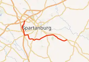
South Carolina Highway 295 (SC 295) is a 16.700-mile (26.876 km) state highway in the northwestern part of the U.S. state of South Carolina. It connects the Spartanburg County communities of Pacolet and Una.
| ||||
|---|---|---|---|---|
| ||||
| Route information | ||||
| Maintained by SCDOT | ||||
| Length | 16.700 mi[1] (26.876 km) | |||
| Existed | 1940–present | |||
| Major junctions | ||||
| South end | ||||
| ||||
| North end | ||||
| Location | ||||
| Counties | Spartanburg | |||
| Highway system | ||||
| ||||

Major intersections
The entire route is in Spartanburg County.
| Location | mi[1] | km | Destinations | Notes | |
|---|---|---|---|---|---|
| | 0.000 | 0.000 | Southern terminus | ||
| Spartanburg | 5.730 | 9.222 | |||
| | 9.520 | 15.321 | Interchange | ||
| Spartanburg | 11.720 | 18.862 | Southern end of SC 296 concurrency | ||
| 12.620 | 20.310 | Northern end of SC 296 concurrency; northern terminus of SC 215 | |||
| 13.620 | 21.919 | ||||
| Saxon–Southern Shops line | 16.700 | 26.876 | Northern terminus; I-85 Bus. exit 3; access to I-85 Bus. via Simuel Road and New Cut Road; Simuel continues past termius. | ||
1.000 mi = 1.609 km; 1.000 km = 0.621 mi
| |||||
See also
 U.S. roads portal
References
- "Highway Logmile Report". South Carolina Department of Transportation. Retrieved December 27, 2020.
External links
 Media related to South Carolina Highway 295 at Wikimedia Commons
- SC 295 at Virginia Highways' South Carolina Highways Annex
This article is issued from Wikipedia. The text is licensed under Creative Commons - Attribution - Sharealike. Additional terms may apply for the media files.