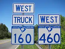
South Carolina Highway 460
South Carolina Highway 460 (SC 460) is a 7.5-mile (12.1 km) primary state highway in the U.S. state of South Carolina. It serves as an bypass of SC 160, from Tega Cay to east of Fort Mill.
| ||||
|---|---|---|---|---|
 | ||||
| Route information | ||||
| Maintained by SCDOT | ||||
| Length | 7.5 mi[1] (12.1 km) | |||
| Existed | 2012–present | |||
| Major junctions | ||||
| West end | ||||
| East end | ||||
| Location | ||||
| Counties | York | |||
| Highway system | ||||
| ||||
Route description

SC 460 begins at the intersection SC 160 and Gold Hill Road, in Tega Cay. Traveling east, along Gold Hill Road, it connects with Interstate 77 (I-77), then soon after splits from Gold Hill Road at Deerfield Drive intersection, continuing as Springfield Parkway. Connecting with U.S. Route 21 (US 21), it begins a concurrency with SC 160 Truck, followed by a quick concurrency with US 21 Business. Reaching back with SC 160, on the eastern side of Fort Mill, the highway ends with SC 160 Truck.[1]
The speed limit for most of SC 460 is 45 miles per hour (72 km/h), with 35 miles per hour (56 km/h) around the I-77 interchange. The Gold Hill Road segment is four-lane with turning median; it is also known as the Becky Meacham-Richardson Highway, who served as a state representative for the Lake Wylie–Tega Cay area. The Springfield Parkway segment is two-lane with semi-controlled access.
History
SC 460 appeared around 2012 as a new primary route, following existing Gold Hill Road and Springfield Parkway.[2]
Major intersections
The entire route is in York County.
| Location | mi[3] | km | Destinations | Notes | |
|---|---|---|---|---|---|
| Tega Cay | 0.000 | 0.000 | Western terminus; Gold Hill Road continues to the west. | ||
| | 2.110 | 3.396 | I-77 exit 88 | ||
| | 3.300 | 5.311 | Western end of SC 160 Truck concurrency | ||
| | 3.670 | 5.906 | Western end of US 21 Bus. concurrency | ||
| | 4.280 | 6.888 | Eastern end of US 21 Bus. concurrency | ||
| Fort Mill | 7.510 | 12.086 | Eastern end of SC 160 Truck concurrency; eastern terminus | ||
1.000 mi = 1.609 km; 1.000 km = 0.621 mi
| |||||
See also
 U.S. roads portal
References
- Google (December 23, 2020). "South Carolina Highway 460" (Map). Google Maps. Google. Retrieved December 23, 2020.
- "Mapmikey's South Carolina Highways Page: SC 460". May 17, 2015. Retrieved December 23, 2020.
- "Highway Logmile Report". South Carolina Department of Transportation. Retrieved November 22, 2020.
External links
| Wikimedia Commons has media related to South Carolina Highway 460. |
