Stuarts Creek, South Australia
Stuarts Creek is a remote locality in the Australian state of South Australia in the states's Far North region.[1] The name and boundaries were formalised on 26 April 2013, named after Stuart Creek Station, in respect of the long established local name.[1]
| Stuarts Creek South Australia | |||||||||||||||
|---|---|---|---|---|---|---|---|---|---|---|---|---|---|---|---|
 | |||||||||||||||
 Stuarts Creek | |||||||||||||||
| Coordinates | 29°37′52″S 137°02′56″E[1] | ||||||||||||||
| Population | 0 (2016 census)[2] | ||||||||||||||
| Established | 26 April 2013[1] | ||||||||||||||
| Postcode(s) | 5720 | ||||||||||||||
| Time zone | ACST (UTC+9:30) | ||||||||||||||
| • Summer (DST) | ACDT (UTC+10:30) | ||||||||||||||
| LGA(s) | Pastoral Unincorporated Area[1] | ||||||||||||||
| Region | Far North[1] | ||||||||||||||
| State electorate(s) | |||||||||||||||
| Federal Division(s) | Grey[5] | ||||||||||||||
| |||||||||||||||
| |||||||||||||||
| Footnotes | Adjoining localities[1] | ||||||||||||||
It includes the former settlement of Coward Springs.[7] The Wabma Kadarbu Mound Springs Conservation Park lies in the north-west of the locality.[8]
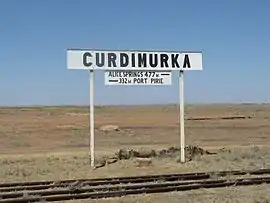
The Central Australia Railway (often referred to as the "Old Ghan") ran through Stuarts Creek, with former stations or sidings at Coward Springs, Margaret, and Stuart Creek (later Curdimurka) all within its current boundaries. The railway remnants at Coward Springs and Curdimurka are both listed on the South Australian Heritage Register.[1][8]
The 2016 Australian census which was conducted in August 2016 reports that Stuarts Creek had no people living within its boundaries.[2]
Stuarts Creek is located within the federal division of Grey, the state electoral districts of Giles and Stuart and the Pastoral Unincorporated Area of South Australia.[5][1][3][4]
Heritage listings
Stuarts Creek has a number of heritage-listed sites, including:
See also
- Marree, South Australia#Climate, nearest weather station
References
- "Search results for 'Stuarts Creek, LOCB' with the following datasets being selected - 'Suburbs and Localities', 'Local Government Areas', 'SA Government Regions', 'Gazetteer', 'Railways' and 'Roads'". Location SA Map Viewer. Government of South Australia. Retrieved 22 March 2019.
- Australian Bureau of Statistics (27 June 2017). "Stuarts Creek (State Suburb)". 2016 Census QuickStats. Retrieved 22 March 2019.

- "District of Giles Background Profile". ELECTORAL COMMISSION SA. Retrieved 22 March 2019.
- "District of Stuart Background Profile". ELECTORAL COMMISSION SA. Retrieved 22 March 2019.
- "Federal electoral division of Grey, boundary gazetted 16 December 2011" (PDF). Australian Electoral Commission. Retrieved 20 August 2015.
- "Monthly climate statistics: Summary statistics MARREE AERO (nearest weather station)". Commonwealth of Australia , Bureau of Meteorology. Retrieved 22 March 2019.
- "Search results for 'Coward Springs Railway Station' with the following datasets being selected - 'Suburbs and Localities', 'Gazetteer' and 'Railways'". Location SA Map Viewer. Government of South Australia. Retrieved 21 March 2019.
- "Search results for 'Stuarts Creek, LOCB' with the following datasets being selected - 'NPW and Conservation Properties', 'Suburbs and Localities', 'Gazetteer', 'Railways', 'SA Heritage Places' and 'Pastoral Stations'". Location SA Map Viewer. Government of South Australia. Retrieved 22 March 2019.
- "Coward Springs Railway Site, including the railway station master's house, the engine driver's cabin, the original bore, rainwater tanks, date palms and tamarisk trees". South Australian Heritage Register. Department of Environment, Water and Natural Resources. Archived from the original on 15 February 2016. Retrieved 11 February 2016.
- "Former Mount Hamilton Station Site (Ruins) (designated place of archaeological significance), Wabma Kadarbu Mound Springs Conservation Park". South Australian Heritage Register. Department of Environment, Water and Natural Resources. Retrieved 11 February 2016.
- "Curdimurka (formerly Stuart Creek) Railway Siding Complex, including fettlers' quarters, water treatment plant, water tank and Stuart Creek Bridge [Metal Girder]". South Australian Heritage Register. Department of Environment, Water and Natural Resources. Retrieved 11 February 2016.
- "Tertiary Silcrete Flora, Stuarts Creek". South Australian Heritage Register. Department of Environment, Water and Natural Resources. Retrieved 11 February 2016.