Tafelberg (Curaçao)
Tafelberg (Table Mountain) is a large flat-topped hill in Curaçao, an island state in the Dutch Caribbean.
| Tafelberg | |
|---|---|
| Table Mountain | |
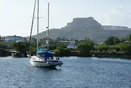 In 2010, with much of the right-hand side already removed by mining | |
| Highest point | |
| Elevation | 196.1[1] m (643 ft) |
| Coordinates | 12°4′N 68°50′W |
| Geography | |
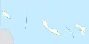 Tafelberg | |
The Tafelberg mesa is in southeastern Curaçao, near the Santa Barbara beach. It is 196.1 metres (643 ft) high, making it only the fourth-highest point on Curaçao behind the 372 metres (1,220 ft) Christoffelberg and two intermediate peaks, all in the volcanic northwest of the island. It is formed mostly of the Quaternary[lower-roman 1] limestone that forms the south-east of Curaçao, although there are also commercially-significant phosphate and calcareous sand deposits.
Fossils of Pleistocene[lower-roman 2] giant tortoises, Chelonoidis, of an estimated 80 centimetres (31 in) carapace length have been found in fill deposits.[2][lower-roman 3]
The vegetation of the area is sparse, owing to the endemic lack of water on Curaçao. Comparisons of grazed and inaccessibly ungrazed areas show that the natural vegetation was predominantly of the bromeliad Tillandsia flexuosa,[lower-roman 4] but that this could not tolerate grazing and since the introduction of livestock by humans, primarily goats, has largely been replaced by annual grasses, prickly pear and shrubby acacias.[3]
Mining
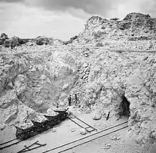
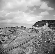
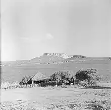
Phosphate mining began at Santa Barbara in the 1870s, although by 1900 it had been abandoned and the island was in an economically near-derelict state.[4]:38[5] Mining stopped in 1891, largely owing to a dispute between the landowner and John Godden,[lower-roman 5] the English operator of the mine, and the last exports were in 1895, after 175,000 tons had been exported.[4]:56 It re-opened though in 1913[4]:57 and was still in operation at the time of Willem van de Poll's visit in 1947. From 1914, the entire economy of Curaçao was re-invigorated by the construction of the Isla oil refinery to refine Venezuelan crude oil.[7]:230–232 The first railway on the island was built for phosphate traffic, a gravity-worked cable funicular from the mountain to the harbour on Fuikbaai near Nieuwpoort.[8]
Limestone is also mined in the area and with the great expansion and prosperity post-WWII, this was in demand for the production of cement and, with local sand, concrete for local construction, aided by cheap fuel as distillation waste from the refinery. By the 1960s, this had led to a perceptible change in the shape of the mountain when viewed from a distance. To preserve its appearance, mining since has adopted a 'hollow-tooth' strategy, where mining proceeds and has hollowed out much of the volume of the mountain, whilst preserving its outer periphery, at least for the remaining Northern face.[9]
References
| Wikimedia Commons has media related to Tafelberg, Curaçao. |
- Up to 2.5 million years old – recent in geological terms
- i.e. first epoch of the Quaternary
- These were assigned to the genus Geochelone when first found, but the South American Geochelones have since been re-classified.
- These Tillandsia species are so drought tolerant that they are sometimes sold as 'airplants', as they are able to survive in a domestic house without watering, merely on atmospheric humidity.
- Godden was the mining engineer who had spurred 'guano mania' in the Dutch Antilles, with his discovery in 1871 of exploitable deposits on Klein Curaçao, San Nicolaas on Aruba and at Tafelberg.[6]
- according to the official cadastral map (1993)
- Amaral, Afrânio Do. (1963). "Geochelone from the Pleistocene of Curaçao, Netherlands Antilles". Copeia (3): 579–580. doi:10.2307/1441492. JSTOR 1441492.
- Debrot, Adolphe O.; De Freitas, John A. (1993). "A Comparison of Ungrazed and Livestock-Grazed Rock Vegetations in Curacao". Biotropica. 25 (3): 270–280. doi:10.2307/2388785. JSTOR 2388785.
- Van Soest, Jaap (1977). "Curaçao and its Economy at the Turn of the Century". Social and Economic Studies. 26 (1): 38–62. JSTOR 27861640.
- Cleland, Herdman F. (1909). "Curacao, a Losing Colonial Venture". Bulletin of the American Geographical Society. 41 (3): 129–138. doi:10.2307/200704. JSTOR 200704.
- "Phosphate". Historia di Aruba.
- Van Soest, Jaap (1980). "On The Account Of Curaçao: Two Centuries of Fiscal Legislation for Trade and Industry". Social and Economic Studies. 29 (2/3): 220–246. JSTOR 27861891.
- See File:Transport bij de fosfaatmijn van het bedrijf Curaçao bij de Tafelberg op Curaçao, Bestanddeelnr 252-7412.jpg
- Steve Bennett (27 May 2016). "Curaçao's Curious Tafelberg Mountain". Uncommon Caribbean. Retrieved 5 April 2019.