The National Forest (England)
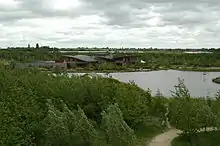
The National Forest is an environmental project in central England run by The National Forest Company. From the 1990s, 200 square miles (520 km2) of north Leicestershire, south Derbyshire and southeast Staffordshire have been planted in an attempt to blend ancient woodland with newly planted areas to create a new national forest. It stretches from the western outskirts of Leicester in the east to Burton upon Trent in the west, and is planned to link the ancient forests of Needwood and Charnwood.

In January 2018 the UK government unveiled plans to create a new English Northern Forest[1] extending from Liverpool to Hull.[2] It will shadow the path of the east-west M62 motorway.[3]
The National Forest Company

The National Forest Company is a not-for-profit organisation established in April 1995 as a company limited by guarantee.[4] It is supported by the Department for Environment, Food and Rural Affairs (Defra), with the aim of converting one third of the land within the boundaries of the National Forest (52 sq mi, 33,000 acres) to woodland, by encouraging landowners to alter their land use. It is described as "a forest in the making" and it is hoped to increase tourism and forestry-related jobs in the area.
Around 8.5 million trees have been planted, more than tripling the woodland cover from 6% to 20%.[5]
Planting
Approximately 85% of the trees planted are native broadleaf species. Some of the most commonly planted species are: English oak, ash, poplar, Corsican pine and Scots pine.[4]
The transformation of the landscape is beginning to take effect as the first tiny whips planted in the early 1990s are growing into substantial trees.
Attractions

At the centre of the National Forest, is Conkers, a visitor centre located just outside the village of Moira, Leicestershire. There is also a visitor centre with wildlife walks and playgrounds at Rosliston.
Other attractions include:
- Ashby Canal
- Ashby Castle, Ashby-de-la-Zouch
- Ashby de-la-Zouch museum, Ashby de-la-Zouch
- Bardon Hill - highest point in the National Forest at 912 feet (278 m) above sea level
- Battlefield Line Railway
- Beacon Hill, Leicestershire
- Bradgate Park
- Calke Abbey, Ticknall
- Claymills Victorian Pumping Station
- Croxall Lakes
- Donington le Heath Manor House
- Flagship Diamond Wood
- Foremark Reservoir, Foremark
- Fradley Junction
- Grace Dieu Priory
- Kedleston Hall
- Loughborough Outwoods
- Melbourne Hall
- Moira Furnace
- Mount St. Bernard Abbey
- National Memorial Arboretum
- Rosliston Forestry Centre
- Seale Wood
- Sence Valley Forest Park
- Sharpe's Pottery Museum
- Staunton Harold Reservoir
- Sudbury Hall
- Swithland Wood
- The National Forest Maze
- T.G.Green Cornishware Archive Museum
- Thornton Reservoir
- Tropical Birdland, Leicestershire
- Twycross Zoo
The towns of Ashby de la Zouch, Burton upon Trent, Swadlincote and Coalville are located within the forest area.
References
- Perraudin, Frances (7 January 2018). "Government pledges £5.7m to develop new northern forest". The Guardian. Retrieved 16 November 2019.
- O'Sullivan, Feargus. "Britain's Next Megaproject: A Coast-to-Coast Forest". CityLab.
- Harrabin, Roger (7 January 2018). "Plan to grow new Northern Forest" – via www.bbc.com.
- "About the National Forest | National Forest". www.nationalforest.org.
- "About Us". National Forest. Retrieved 7 January 2018.
External links
| Wikimedia Commons has media related to The National Forest (England). |