Wadhurst Clay Formation
The Wadhurst Clay Formation is a geological unit which forms part of the Wealden Group and the middle part of the now unofficial Hastings Beds. These geological units make up the core of the geology of the High Weald in the English counties of West Sussex, East Sussex and Kent.
| Wadhurst Clay Formation Stratigraphic range: Valanginian | |
|---|---|
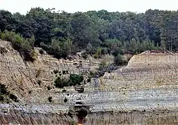
 Wadhurst Clay (grey) exposed at Bexhill Brick Pit | |
| Type | Geological formation |
| Unit of | Wealden Group |
| Underlies | Tunbridge Wells Sand Formation |
| Overlies | Ashdown Formation |
| Thickness | 30 to 78 m |
| Lithology | |
| Primary | Shale, Mudstone |
| Other | Siltstone, Sandstone, Limestone, Ironstone |
| Location | |
| Region | Europe |
| Country | |
| Extent | Weald Basin |
| Type section | |
| Named for | Wadhurst |
The other component formations of the Hastings Beds are the underlying Ashdown Formation and the overlying Tunbridge Wells Sand Formation. The Hastings Beds in turn form part of the Wealden Group which underlies much of southeast England. The sediments of the Weald, including the Wadhurst Clay Formation, were deposited during the Early Cretaceous Period, which lasted for approximately 40 million years from 140 to 100 million years ago. The Wadhurst Clay is of Early to Late Valanginian age.[1] The Formation takes its name from the market town of Wadhurst in East Sussex.
Lithology

The Wadhurst Clay comprises predominantly medium to dark bluish grey over-consolidated clays, silts, mudstones, and shales. These lithologies often occur with subordinate amounts of pale grey silty mudstones, laminated siltstones, sandstones, conglomerate, shelly limestones and clay-ironstones.[2] When they become exposed to the elements at the surface, the mudstones often degrade over a short period of time and weather to yellowish brown and greenish grey clays.[3]
The formation thickness ranges from 55m in the Tenterden area, to 30m near Lewes and varies in between. In Kent, the Wadhurst Clay has been proven to over 70m thick near Tunbridge Wells [2] and in West Sussex up to 80m near Horsham.[4]
The base of the Wadhurst Clay is taken at the bottom of the Top Ashdown Pebble Bed. The base of this marker horizon marks the formational change to the Ashdown Formation. Despite its name this thin and impressistent bed comprises a coarse grained to gravelly sandstone. This horizon is best exposed at Cliff End, East Sussex, but where it is encountered elsewhere, it is usually fairly distinctive and easily identified. The Top Ashdown Pebble Bed occurs mainly in the southern half of East Sussex and is often missing elsewhere. Where this is the case, the boundary is taken at a layer of disconnected ripples.[5]
The top of the Wadhurst Clay is marked by a distinct lithological change into the siltstones of the Tunbridge Wells Sand Formation. The uppermost clays of the Wadhurst Clay, closest to the boundary are often stained red.[1]

Engineering Geology
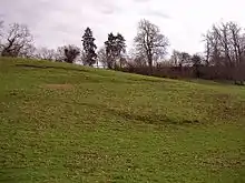
Natural slopes in the Wadhurst Clay, like those in the Ashdown Formation, are known for their instability, especially where impermeable clays and impermeable silts and siltstones are interbedded. Instability, resulting in landslips, often occurs along shear surfaces and weaknesses that originally developed during the Late Devensian glaciation. Other common features include cambering, valley bulging and solifluction lobes.
Landslips often occur at or close to the upper boundary of the Wadhurst Clay, which is shared with the overlying Tunbridge Wells Sand Formation. This is partly caused by the steep sided hill, valley and ravine topography of the High Weald and partly by the lithological variation between the formations and the presence of spring lines and seepages.[3]
When percolating groundwater in the permeable sandstones of the Tunbridge Wells Sands comes into contact with the upper impermeable clay beds of the Wadhurst Clay, it is forced to find alternative migration pathways to the surface. This results in the saturation and weakening of the upper portion of the Wadhurst Clay, increasing the chances of failure.[3]
Paleobiota
Taken from [6]
Dinosaurs
| Dinosaurs reported from the Wadhurst Clay | ||||||
|---|---|---|---|---|---|---|
| Genus | Species | Location | Stratigraphic position | Material | Notes | Images |
| Altispinax | A. dunkeri | Hollington Quarry | Tooth | Originally known as Megalosaurus dunkeri | ||
| Barilium | B. dawsoni[7] | Shornden Quarry, Old Roar Quarry, | "[Two] partial skeletons."[8] | An iguanodontian | ||
| Hypselospinus | H. fittoni[9] | Hollington Quarry, Shornden Quarry, Hare Farm Lane, Brede | Partial skeletons | An iguanodontian |  | |
| Suchosaurus | S. cultridens | Hare Farm Lane, Brede | Teeth | A spinosaurid | ||
| Unnamed maniraptoran | Indeterminate | Ashdown Brickworks | Specimen BEXHM: 2008.14.1[10] A single cervical vertebra | Possibly an oviraptorosaur[10] | ||
Amphibians
| Crocodyliformes reported from the Wadhurst Clay | ||||||
|---|---|---|---|---|---|---|
| Genus | Species | Location | Stratigraphic position | Material | Notes | Images |
| Anura | Indeterminate | Ashdown Brickworks | Two fragmentary ilia | At least 2 taxa[11] | ||
| Urodela | Indeterminate | Atlas and postatlas vertebrae, dentary, maxilla and vomer fragments | At least 3 taxa distinguishable by their atlas vertebrae[11] | |||
Crocodyliformes
| Crocodyliformes reported from the Wadhurst Clay | ||||||
|---|---|---|---|---|---|---|
| Genus | Species | Location | Stratigraphic position | Material | Notes | Images |
| Goniopholis | G. crassidens | Hare Farm Lane, Brede | A Goniopholid Neosuchian. |  | ||
Mammals
| Mammals reported from the Wadhurst Clay | ||||||
|---|---|---|---|---|---|---|
| Genus | Species | Location | Stratigraphic position | Material | Notes | Images |
| Laolestes | L. hodsoni | Cliff End bonebed, Tighe Farm | Cypridea paulsgrovensis ostracod Zone | Dryolestid | ||
| Spalacotherium | S. tricuspidens | Cliff End bonebed | Spalacotheriid | |||
| Aegialodon | A. dawsoni | Cladotherian | ||||
| Loxaulax | L. valdensis | Eobataarid multituberculate | ||||
Plesiosaurians
| Plesiosaurians reported from the Wadhurst Clay | ||||||
|---|---|---|---|---|---|---|
| Genus | Species | Location | Stratigraphic position | Material | Notes | Images |
| Hastanectes | H. valdensis | Old Roar Quarry, Hollington Quarry, Black Horse Quarry, Hastings, Brenchley | ||||
References
- Hopson, P.M., Wilkinson, I.P. and Woods, M.A. (2010) A stratigraphical framework for the Lower Cretaceous of England. Research Report RR/08/03. British Geological Survey, Keyworth.
- Lake, R.D. & Shepard-Thorn, E.R. (1987) Geology of the country around Hastings and Dungeness: Memoir for 1:50,000 geological sheets 320 and 321. British Geological Survey, London.
- Codd, J.W. (2007) Analysis of the distribution and characteristics of landslips in the Weald of East Sussex. MSc dissertation, University of Brighton.
- Reeves, G.M., Sims, I., & Cripps, J.C. (2006) Clay Minerals Used in Construction, Geological Society, London, Engineering Geology Special Publication, 21, 153-175.
- Lake, Shepard-Thorn, E.R., Smart, J.G.O., Bisson, G. & Edmonds, E.A. (1966) Geology of the country around Tenterden: Memoir for 1:50,000 geological sheet 304. British Geological Survey, London.
- "Wadhurst Clay Formation". Paleobiology Database.
- "10.19 East Sussex, England; 1. Hastings Beds" in Weishampel, et al. (2004). Page 559.
- "Table 19.1," in Weishampel, et al. (2004). Page 416.
- "10.19 East Sussex, England; 1. Hastings Beds" in Weishampel, et al. (2004). Page 559.
- Naish, D. and Sweetman, S.C. (2011). "A tiny maniraptoran dinosaur in the Lower Cretaceous Hastings Group: evidence from a new vertebrate-bearing locality in south-east England." Cretaceous Research, 32: 464-471. doi:10.1016/j.cretres.2011.03.001
- Sweetman, S.C; Evans, S. E. (2011). "Lissamphibians (frogs, salamanders and albanerpetontids)". English Wealden fossils. Palaeontological Association. ISBN 978-1-4443-6711-9. OCLC 777385514.CS1 maint: multiple names: authors list (link)